Countries
Mapping the World’s Overseas Territories and Dependencies
Article/Editing:
View a higher resolution version of this graphic.

Overseas Territories and Dependencies of the World
An overseas territory or dependency is a region with ties abroad to a sovereign nation—not a completely independent state, but also not a constituent part or administrative subdivision of the parent country.
Their histories vary, but most are tied to either “modern” colonialism from the 1400s onwards, or wars from the 19th and 20th centuries. Many of these regions still depend on their parent country to some capacity for economic, military, and diplomatic affairs.
This graphic by Pranav Gavali maps the overseas territories of various countries, using a variety of sources including WorldAtlas, Statista, and official country releases.
Where are the World’s Overseas Territories and Dependencies?
There are a total of 71 overseas territories listed on the map spread across the world.
It excludes territories claims in Antarctica, which are currently governed by the 1959 Antarctic Treaty. As an overseas map, it also excludes territories sharing a border, or that are part of a larger state or province (like Germany’s Heligoland, part of the state of Schleswig-Holstein).
Each region has its own unique present-day status. Some are “autonomous territories” or “constituent countries,” while some are administered almost entirely as part of the parent country.
| Sovereign | Overseas Territory / Dependency | Region |
|---|---|---|
| 🇦🇺 Australia | Ashmore and Cartier Islands | Indian Ocean |
| 🇦🇺 Australia | Christmas Island | Indian Ocean |
| 🇦🇺 Australia | Cocos (Keeling) Islands | Indian Ocean |
| 🇦🇺 Australia | Coral Sea Islands | Pacific Ocean |
| 🇦🇺 Australia | Heard & McDonald Islands | Indian Ocean |
| 🇦🇺 Australia | Norfolk Island | Pacific Ocean |
| 🇩🇰 Denmark | Faroe Islands | Atlantic Ocean |
| 🇩🇰 Denmark | Greenland | Atlantic Ocean / Arctic Ocean |
| 🇫🇷 France | Bassas da India | Indian Ocean |
| 🇫🇷 France | Clipperton Island | Pacific Ocean |
| 🇫🇷 France | Europa Island | Indian Ocean |
| 🇫🇷 France | French Guiana | South America |
| 🇫🇷 France | French Polynesia | Pacific Ocean |
| 🇫🇷 France | Glorioso Islands | Indian Ocean |
| 🇫🇷 France | Guadeloupe | Caribbean |
| 🇫🇷 France | Juan de Nova Island | Indian Ocean |
| 🇫🇷 France | Martinique | Caribbean |
| 🇫🇷 France | Mayotte | Indian Ocean |
| 🇫🇷 France | New Caledonia | Pacific Ocean |
| 🇫🇷 France | Réunion | Indian Ocean |
| 🇫🇷 France | Saint Barthélemy | Caribbean |
| 🇫🇷 France | Saint Pierre and Miquelon | Atlantic Ocean |
| 🇫🇷 France | Saint-Martin | Caribbean |
| 🇫🇷 France | Tromelin Island | Indian Ocean |
| 🇫🇷 France | Wallis and Futuna | Pacific Ocean |
| 🇳🇱 Netherlands | Aruba | Caribbean |
| 🇳🇱 Netherlands | Bonaire | Caribbean |
| 🇳🇱 Netherlands | Curaçao | Caribbean |
| 🇳🇱 Netherlands | Saba | Caribbean |
| 🇳🇱 Netherlands | Sint Eustatius | Caribbean |
| 🇳🇱 Netherlands | Sint Maarten | Caribbean |
| 🇳🇿 New Zealand | Cook Islands | Pacific Ocean |
| 🇳🇿 New Zealand | Niue | Pacific Ocean |
| 🇳🇿 New Zealand | Tokelau | Pacific Ocean |
| 🇳🇴 Norway | Bouvet Island | Atlantic Ocean |
| 🇳🇴 Norway | Jan Mayen | Arctic Ocean |
| 🇳🇴 Norway | Peter I Island | Southern Ocean |
| 🇳🇴 Norway | Svalbard | Arctic Ocean |
| 🇵🇹 Portugal | Azores | Atlantic Ocean |
| 🇵🇹 Portugal | Madeira | Atlantic Ocean |
| 🇬🇧 United Kingdom | Akrotiri (British Forces) | Cyprus / Mediterranean |
| 🇬🇧 United Kingdom | Anguilla | Caribbean |
| 🇬🇧 United Kingdom | Bermuda | Atlantic Ocean |
| 🇬🇧 United Kingdom | British Indian Ocean Territory | Indian Ocean |
| 🇬🇧 United Kingdom | British Virgin Islands | Caribbean |
| 🇬🇧 United Kingdom | Cayman Islands | Caribbean |
| 🇬🇧 United Kingdom | Dhekelia (British Forces) | Cyprus / Mediterranean |
| 🇬🇧 United Kingdom | Falkland Islands (Islas Malvinas) | Atlantic Ocean |
| 🇬🇧 United Kingdom | Gibraltar | Europe |
| 🇬🇧 United Kingdom | Guernsey (Channel Island) | Atlantic Ocean |
| 🇬🇧 United Kingdom | Isle of Man | Atlantic Ocean |
| 🇬🇧 United Kingdom | Jersey (Channel Island) | Atlantic Ocean |
| 🇬🇧 United Kingdom | Montserrat | Caribbean |
| 🇬🇧 United Kingdom | Pitcairn, Henderson, Ducie & Oeno Islands | Pacific Ocean |
| 🇬🇧 United Kingdom | Saint Helena, Ascension & Tristan da cunha | Atlantic Ocean |
| 🇬🇧 United Kingdom | South Georgia & South Sandwich Islands | Atlantic Ocean |
| 🇬🇧 United Kingdom | Turks & Caicos Islands | Caribbean |
| 🇺🇸 United States | American Samoa | Pacific Ocean |
| 🇺🇸 United States | Baker Island | Pacific Ocean |
| 🇺🇸 United States | Guam | Pacific Ocean |
| 🇺🇸 United States | Howland Island | Pacific Ocean |
| 🇺🇸 United States | Jarvis Island | Pacific Ocean |
| 🇺🇸 United States | Johnston Atoll | Pacific Ocean |
| 🇺🇸 United States | Kingman Reef | Pacific Ocean |
| 🇺🇸 United States | Midway Islands / Atoll | Pacific Ocean |
| 🇺🇸 United States | Navassa Island | Caribbean |
| 🇺🇸 United States | Northern Mariana Islands | Pacific Ocean |
| 🇺🇸 United States | Palmyra Atoll | Pacific Ocean |
| 🇺🇸 United States | Puerto Rico | Caribbean |
| 🇺🇸 United States | U.S. Virgin Islands | Caribbean |
| 🇺🇸 United States | Wake Island | Pacific Ocean |
More than half of the overseas territories were in either the Pacific Ocean (21) or the Caribbean (18). The United States by itself accounts for 11 of the territories spread out across the North and South Pacific.
Another highlight is that the majority of these regions are islands located quite a distance from their parent countries. One of the furthest is New Caledonia, a French territory around 17,000 km away from European France.
They also vary mightily in terms of size, population, and political apparatus. For example, the U.S. territory of Puerto Rico has 3 million people, and its own constitution and elected government, while another U.S. territory of Johnston Atoll is tiny and entirely uninhabited.
Here’s a brief look at some of the best known territories on the list:
Guam
First colonized by Spain in the 16th century, the U.S. occupied the North Pacific islands in the aftermath of the Spanish–American war (along with Puerto Rico and the Philippines). The island was briefly occupied by Japan during World War II—attacked at the same time as Pearl Harbor—before being recaptured by the United States. It currently has an elected legislature and governor and is home to a large U.S. military base.
Bermuda
When Bermuda was first discovered in the 1500s by the Spanish in the Caribbean, and then a century later by the English, there was no Indigenous population documented. At first it was used by passing ships as a replenishment spot, but the English eventually settled it in the 17th century. It now has a constitution, a parliament, and a governor who exercises power on behalf of the British head of state.
Cook Islands
Unlike others on this list, the Cook Islands in the South Pacific is not only self-governing but also runs its own foreign and defense policy and is in “free association” with New Zealand. While Cook Islanders are New Zealand citizens, with the same monarch as head of state, they are also separate Cook Island nationals.
Réunion
This island in the Indian Ocean 700 km off the coast of Madagascar was first settled by the French in the 17th century, though it was discovered earlier by the Portuguese. It is one of the many French Overseas Territories that together are home to 2.6 million people.
Countries With the Most Overseas Territories and Dependencies
Depending on if you count island territories independently or group them together, the final accounting of overseas territories and dependencies by country can vary.
But by most official designations of territories, the UK and France are tied with 17 overseas territories.
| Country | Overseas Territories & Dependences |
|---|---|
| 🇫🇷 France | 17 |
| 🇬🇧 United Kingdom | 17 |
| 🇺🇸 United States | 14 |
| 🇦🇺 Australia | 6 |
| 🇳🇱 Netherlands | 6 |
| 🇳🇴 Norway | 4 |
| 🇳🇿 New Zealand | 3 |
| 🇩🇰 Denmark | 2 |
| 🇵🇹 Portugal | 2 |
Unsurprisingly, two great empires of the past—Britian and France—still have largest remnants of their past breadth. The British still maintain many ties to several territories in the Caribbean (formerly the British West Indies) while French influence stretches from the Pacific to South America.
And consider that this list reflects current status as of 2023. Former colonies that would have been counted in the past include British India (which became India, Pakistan, and Bangladesh) and French Indochina (which became Cambodia, Laos, and Vietnam).
As for the U.S. at #3, though the majority of its territories are in the Pacific, they were acquired well before World War II. In addition to islands ceded by Spain, the rest were unclaimed islands incorporated as part of the Guano Islands Act of 1856, which sought sources of guano—feces of bats and seabirds used as agricultural fertilizer and for gunpowder production.
Editor’s note: The original graphic and article included a source which had incorrect sizes and listed Spain as having two territories. The graphic, article, and relevant tables and overall numbers have been updated.

This article was published as a part of Visual Capitalist's Creator Program, which features data-driven visuals from some of our favorite Creators around the world.


Demographics
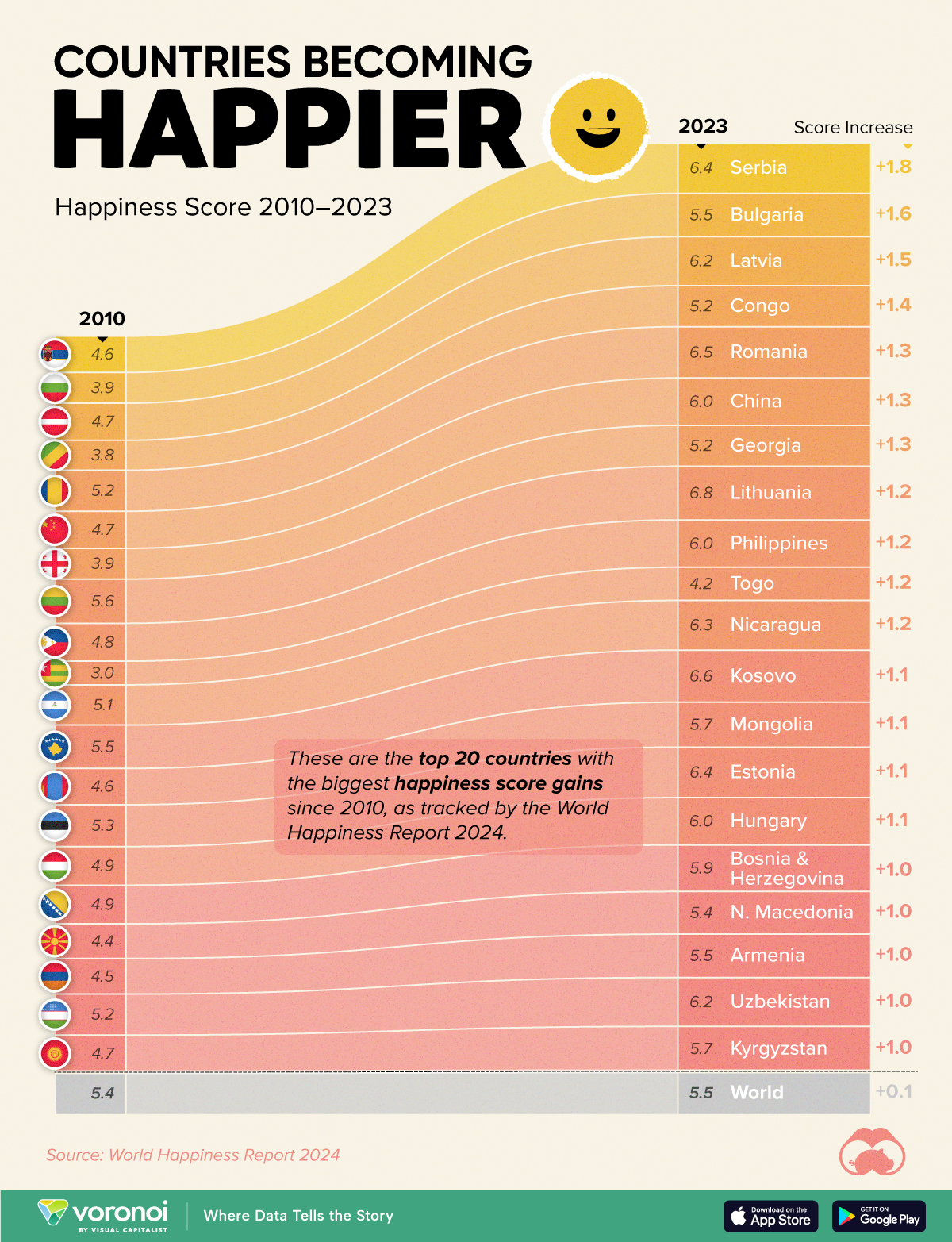
Countries With the Largest Happiness Gains Since 2010
Tracking Gallup survey data for more than a decade reveals insights into the regions seeing happiness gains.
Countries With the Largest Happiness Gains Since 2010
This was originally posted on our Voronoi app. Download the app for free on iOS or Android and discover incredible data-driven charts from a variety of trusted sources.
In 2011, Bhutan sponsored a UN resolution that invited governments to prioritize happiness and well-being as a way to measure social and economic development.
And thus, the World Happiness Report was born.
In 2012, the first report released, examining Gallup poll data from 2006–2010 that asked respondents in nearly every country to evaluate their life on a 0–10 scale. From this they extrapolated a single “happiness score” out of 10 to compare how happy countries are.
More than a decade later, the 2024 World Happiness Report continues the mission to quantify, measure, and compare well-being. Its latest findings also include how countries have become happier in the intervening years.
We visualize these findings in the above chart, which shows the 20 countries that have seen their happiness scores grow the most since 2010.
Which Countries Have Become Happier Since 2010?
Serbia leads a list of 12 Eastern European nations whose average happiness score has improved more than 20% in the last decade.
In the same time period, the Serbian economy has doubled to $80 billion, and its per capita GDP has nearly doubled to $9,538 in current dollar terms.
| Rank | Country | Happiness Score Gains (2010–2024) | 2024 Happiness Score (out of 10) |
|---|---|---|---|
| 1 | 🇷🇸 Serbia | +1.8 | 6.4 |
| 2 | 🇧🇬 Bulgaria | +1.6 | 5.5 |
| 3 | 🇱🇻 Latvia | +1.5 | 6.2 |
| 4 | 🇨🇬 Congo | +1.4 | 5.2 |
| 5 | 🇷🇴 Romania | +1.3 | 6.5 |
| 6 | 🇨🇳 China | +1.3 | 6.0 |
| 7 | 🇬🇪 Georgia | +1.3 | 5.2 |
| 8 | 🇱🇹 Lithuania | +1.2 | 6.8 |
| 9 | 🇵🇭 Philippines | +1.2 | 6.0 |
| 10 | 🇹🇬 Togo | +1.2 | 4.2 |
| 11 | 🇳🇮 Nicaragua | +1.2 | 6.3 |
| 12 | 🇽🇰 Kosovo | +1.1 | 6.6 |
| 13 | 🇲🇳 Mongolia | +1.1 | 5.7 |
| 14 | 🇪🇪 Estonia | +1.1 | 6.4 |
| 15 | 🇭🇺 Hungary | +1.1 | 6.0 |
| 16 | 🇧🇦 Bosnia & Herzegovina | +1.0 | 5.9 |
| 17 | 🇲🇰 North Macedonia | +1.0 | 5.4 |
| 18 | 🇦🇲 Armenia | +1.0 | 5.5 |
| 19 | 🇺🇿 Uzbekistan | +1.0 | 6.2 |
| 20 | 🇰🇬 Kyrgyzstan | +1.0 | 5.7 |
| N/A | 🌍 World | +0.1 | 5.5 |
Since the first report, Western Europe has on average been happier than Eastern Europe. But as seen with these happiness gains, Eastern Europe is now seeing their happiness levels converge closer to their Western counterparts. In fact, when looking at those under the age of 30, the most recent happiness scores are nearly the same across the continent.
All in all, 20 countries have increased their happiness score by a full point or more since 2010, on the 0–10 scale.

-

 Mining1 week ago
Gold vs. S&P 500: Which Has Grown More Over Five Years?
-

 Markets2 weeks ago
Ranked: The Most Valuable Housing Markets in America
-

 Money2 weeks ago
Which States Have the Highest Minimum Wage in America?
-

 AI2 weeks ago
Ranked: Semiconductor Companies by Industry Revenue Share
-

 Markets2 weeks ago
Ranked: The World’s Top Flight Routes, by Revenue
-

 Countries2 weeks ago
Population Projections: The World’s 6 Largest Countries in 2075
-

 Markets2 weeks ago
The Top 10 States by Real GDP Growth in 2023
-

 Demographics2 weeks ago
The Smallest Gender Wage Gaps in OECD Countries