Misc
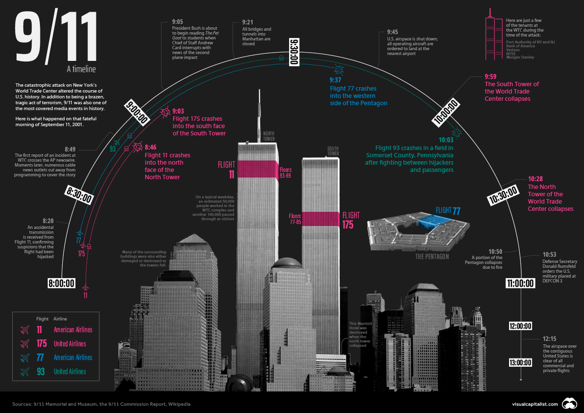
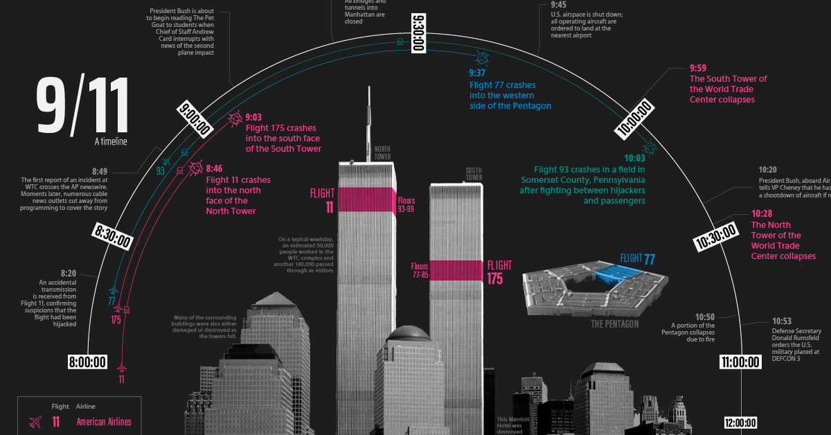
9/11 Timeline: Three Hours That Changed Everything
View the full-size version of this infographic


9/11 Timeline: Three Hours That Changed Everything
For Americans and people watching around the world, September 11, 2001, is a day that will never be forgotten.
Within three hours, New York’s tallest buildings were reduced to rubble, and the Pentagon—the nerve center of the American armed forces—was burning and partially collapsed. Thousands of civilians had lost their lives and were seriously injured, and the entire country was in collective shock, still trying to make sense of how a coordinated act of terrorism of that magnitude was allowed to take place on American soil.
In the 20 years since 9/11, the events that occurred that morning have been analyzed in-depth from a thousand different angles. Even though the attacks took place in the era just before mobile phones had viable cameras, there are countless images and videos of the event. As well, we now have the 9/11 Commission Report, which compiles interviews from over 1,200 people in 10 countries, and draws upon two and a half million pages of documents to present its findings.
For many people younger than Generation X, 9/11 is a feeling—a grim milestone from their youth—but the details are likely more fuzzy. The timeline visualization above is a high-level record of what happened that morning during the three hours when everything changed.
A Chronology of Terror
In its most simple form, the 9/11 attacks can be described as a coordinated hijacking of four commercial airplanes, which were then used to fly into high profile targets in New York City and Washington, DC. Here is a summary of the planes involved in the incident:
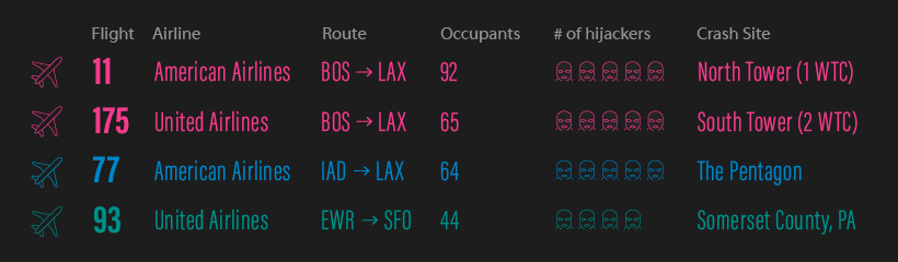
These four flights play a central role in what unfolded that morning. In the early hours of September 11, 2001, a collection of 19 would-be hijackers made their way through security at airports in Boston, Newark, and Washington, DC.
Our three-hour timeline begins just before 8am, as the first plane involved in the attack leaves the tarmac just outside of Boston. (In situations where the exact time isn’t known, a range is given.)
Sept 11, 2001, 7:59am – American Airlines Flight 11, a Boeing 767 carrying 81 passengers and 11 crew members, departs from Logan International Airport in Boston, bound for Los Angeles International Airport.
8:14 – United Airlines Flight 175, a Boeing 767, carrying 56 passengers and 9 crew members, departs from Logan International Airport in Boston, bound for Los Angeles International Airport.
8:14 – Flight 11 is hijacked over central Massachusetts. There are five hijackers on board.
8:20 – American Airlines Flight 77, a Boeing 757 with 58 passengers and 6 crew members, departs from Washington Dulles International Airport, for Los Angeles International Airport.
8:42 – United Airlines Flight 93, a Boeing 757 with 37 passengers and 7 crew members, departs from Newark International Airport, bound for San Francisco International Airport.
8:42–8:46 – Flight 175 is hijacked above northwest New Jersey. There are five hijackers on board.
8:46 – Flight 11 crashes into the north face of the North Tower (1 WTC) of the World Trade Center, between floors 93 and 99. All 92 people on board are killed.
8:50–8:54 – Flight 77 is hijacked above southern Ohio. There are five hijackers on board.
9:03 – Flight 175 crashes into the south face of the South Tower (2 WTC) of the World Trade Center, between floors 77 and 85. All 65 people on board are killed.
9:28 – Flight 93 is hijacked above northern Ohio. There are four hijackers on board.
9:37 – Flight 77 crashes into the western side of The Pentagon. All 64 people on board are killed.
9:45 – United States airspace is shut down; all operating aircraft are ordered to land at the nearest airport.
9:59 – The South Tower of the World Trade Center collapses, 56 minutes after the impact of Flight 175.
10:03 – Flight 93 is crashed by its hijackers in a field in Somerset County, Pennsylvania. Later reports indicate that passengers had learned about the World Trade Center and Pentagon crashes and were resisting the hijackers. All 44 people on board are killed in the crash.
10:28 – The North Tower of the World Trade Center collapses, 1 hour and 42 minutes after the impact of Flight 11. The Marriott Hotel at the base of the two towers is also destroyed.
10:50 – Five stories of the western side of the Pentagon collapse due to the fire.
Two and a half hours after the first plane left Boston, the iconic “Twin Towers” lay in ruins in Lower Manhattan, and brave first responders and military personnel were scrambling to save lives and secure the country.
Life in America was set on a new trajectory.
Information Shockwave
Two decades is a long time in the world of technology and media. Though the communication channels of that era may seem slow by today’s standards, the September 11 terrorist attacks still took place in the age of 24-hour cable news coverage and nascent online reporting.
Add in the fact that New York was (and still is) a linchpin of global media, and it’s easy to see why media coverage of the attack spread so quickly.
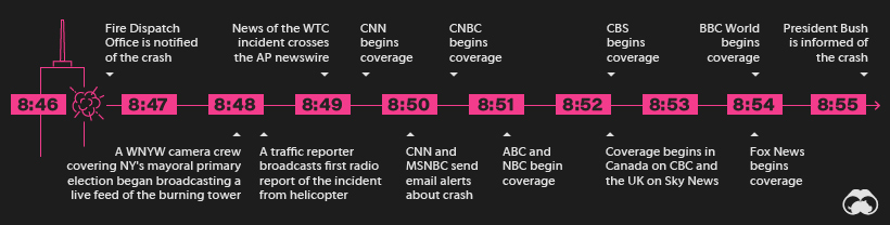
Within two minutes of the first impact on the World Trade Center, a nearby camera crew covering New York’s mayoral primary election was already broadcasting a live feed of the burning building to a TV audience. Within three minutes, news of the attack hit the Associated Press newswire, and moments after that, most major networks cut away from scheduled programming to cover the story.
Less than 10 minutes after the impact, President Bush–who was attending an event at a Florida elementary school–was informed of the crash (which at that point was characterized as an accident).
Because media outlets were able to cover the incident so quickly, millions of people witnessed the second plane striking the South Tower in real-time a mere 17 minutes after the first impact. This was a defining moment as millions of people around the world experience the events precisely as they unfolded.
The still-young internet was strained that day. Moments after the impact of the North Tower, the CNN and MSNBC websites experienced a crushing load of traffic that overwhelmed servers. The FBI’s website also experienced issues after posting the images of the 9/11 hijackers later that day.
Lasting Impact
The Pentagon has been repaired, and a shiny, 94-story World Trade Center now punctuates the skyline of Lower Manhattan, but not all wounds have healed.
For one, many 9/11 survivors are living with lingering health issues believed to be linked to the toxic smoke from the attack and building collapse. Many others are living with the absence of the nearly 3,000 loved-ones who died during the attacks.
The Department of Homeland Security (DHS) is still a lasting legacy of the 9/11 attacks. When DHS began operations in 2003, it was the largest U.S. government reorganization in the 50 years since the Department of Defense was created. In addition to this largely “hidden” layer of security, people now encounter more vigorous security protocol at airports around the world.
As well, the recent withdrawal from Afghanistan was a reminder that long shadow of the attack is still influencing events today, even two decades later.


VC+
VC+: Get Our Key Takeaways From the IMF’s World Economic Outlook
A sneak preview of the exclusive VC+ Special Dispatch—your shortcut to understanding IMF’s World Economic Outlook report.

Have you read IMF’s latest World Economic Outlook yet? At a daunting 202 pages, we don’t blame you if it’s still on your to-do list.
But don’t worry, you don’t need to read the whole April release, because we’ve already done the hard work for you.
To save you time and effort, the Visual Capitalist team has compiled a visual analysis of everything you need to know from the report—and our VC+ Special Dispatch is available exclusively to VC+ members. All you need to do is log into the VC+ Archive.
If you’re not already subscribed to VC+, make sure you sign up now to access the full analysis of the IMF report, and more (we release similar deep dives every week).
For now, here’s what VC+ members get to see.
Your Shortcut to Understanding IMF’s World Economic Outlook
With long and short-term growth prospects declining for many countries around the world, this Special Dispatch offers a visual analysis of the key figures and takeaways from the IMF’s report including:
- The global decline in economic growth forecasts
- Real GDP growth and inflation forecasts for major nations in 2024
- When interest rate cuts will happen and interest rate forecasts
- How debt-to-GDP ratios have changed since 2000
- And much more!

Get the Full Breakdown in the Next VC+ Special Dispatch
VC+ members can access the full Special Dispatch by logging into the VC+ Archive, where you can also check out previous releases.
Make sure you join VC+ now to see exclusive charts and the full analysis of key takeaways from IMF’s World Economic Outlook.
Don’t miss out. Become a VC+ member today.
What You Get When You Become a VC+ Member
VC+ is Visual Capitalist’s premium subscription. As a member, you’ll get the following:
- Special Dispatches: Deep dive visual briefings on crucial reports and global trends
- Markets This Month: A snappy summary of the state of the markets and what to look out for
- The Trendline: Weekly curation of the best visualizations from across the globe
- Global Forecast Series: Our flagship annual report that covers everything you need to know related to the economy, markets, geopolitics, and the latest tech trends
- VC+ Archive: Hundreds of previously released VC+ briefings and reports that you’ve been missing out on, all in one dedicated hub
You can get all of the above, and more, by joining VC+ today.

-

 Education1 week ago
How Hard Is It to Get Into an Ivy League School?
-

 Technology2 weeks ago
Ranked: Semiconductor Companies by Industry Revenue Share
-

 Markets2 weeks ago
Ranked: The World’s Top Flight Routes, by Revenue
-

 Demographics2 weeks ago
Population Projections: The World’s 6 Largest Countries in 2075
-

 Markets2 weeks ago
The Top 10 States by Real GDP Growth in 2023
-

 Demographics2 weeks ago
The Smallest Gender Wage Gaps in OECD Countries
-

 Economy2 weeks ago
Where U.S. Inflation Hit the Hardest in March 2024
-

 Green2 weeks ago
Top Countries By Forest Growth Since 2001