Misc
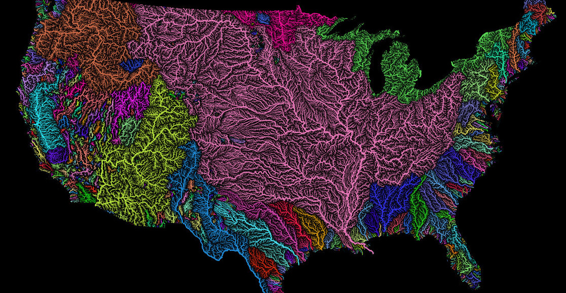
Beautiful Maps of the World’s Watersheds
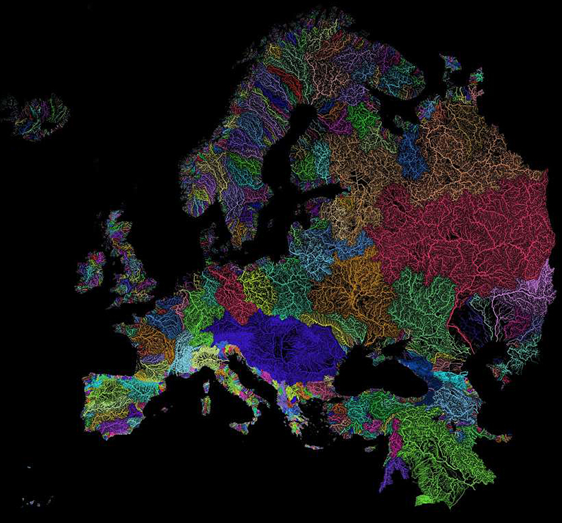
Nothing is more fundamental to life than water – and this is particularly evident in a country like Egypt, which has been aptly described by Greek historian Herodotus as the “Gift of the Nile”.
In Egypt, an astonishing 95% of the population lives alongside the mighty Nile, which is the world’s longest river at 4,258 mi (6,853 km) and also the only major source of freshwater in an otherwise arid desert landscape.
The World’s Watersheds
The Nile isn’t alone in creating the right conditions for life. Rivers of all sizes help form the world’s watersheds, and together they comprise a “circulatory system” that pumps life into every corner of the globe.
Today’s stunning maps, via geographer Szűcs Róbert, divide our planet’s watersheds into colorful catchment areas, and provide an informative look at how water flows across continents.
When Rivers Take the Long Way ‘Round
Grade school physics teaches us that liquid water will take the most available path of least resistance. Sometimes though, that most available path can take water from mountains clear across a continent before reaching an ocean.
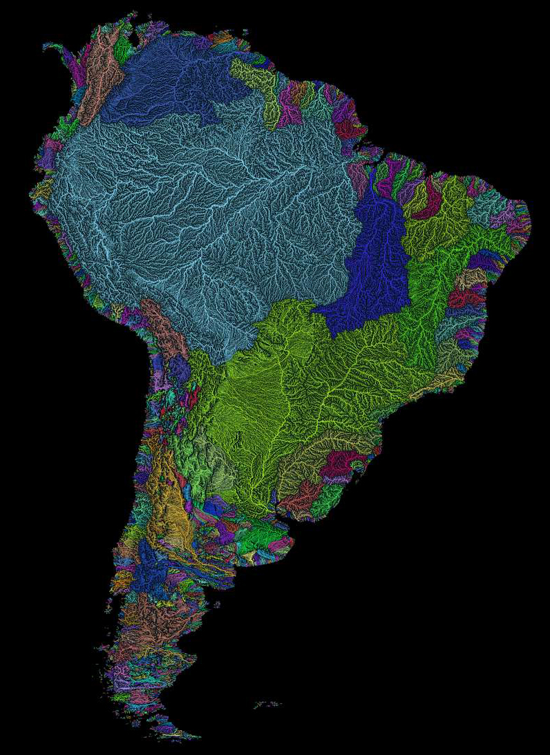
Nowhere is this more evident than in Peru, home of the glacier-packed Cordillera Blanca. As rain and meltwater begins flowing from the peaks of the Andes Mountains, there are two diverging paths to the ocean.
The journey to the Pacific Ocean is a quick one, and there are small rivers at regular intervals along the coast of Peru.
Because trade winds blow east-to-west in that region, most of the water flows down the eastern side of the Andes, the beginning of a journey across the continent (as demonstrated by the light blue section of Róbert’s South America map.)
Without the Andes acting as a backstop for rain, the Amazon rainforest would not exist in its current scale and form.
When Three Become One
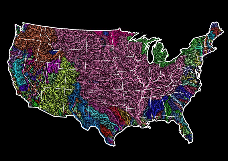
In the United States, the dominant drainage basin is the Jefferson-Mississippi-Missouri River system (shown in pink on the map above.) This massive basin collects water from over 40% of the contiguous U.S., and comes into contact with two Canadian provinces and 31 states before terminating at the Gulf of Mexico.
The Top Ranked Rivers
The Amazon discharges far more water than any other river on earth, dumping more water per second into the ocean than the next four largest rivers combined. That makes the Amazon a clear winner in this category.
In terms of drainage area though, the Amazon is not as dominant:
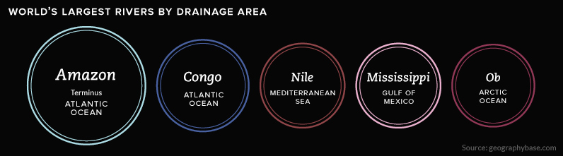
In fact, there are multiple rivers that cover massive drainage areas. This includes the Congo in Africa, as well as the mighty Mississippi, which is neck-and-neck with the Nile.
For more, view the full collection of maps here.


United States
Charted: What Southeast Asia Thinks About China & the U.S.
A significant share of respondents from an ASEAN-focused survey are not happy about rising American and Chinese influence in the region.
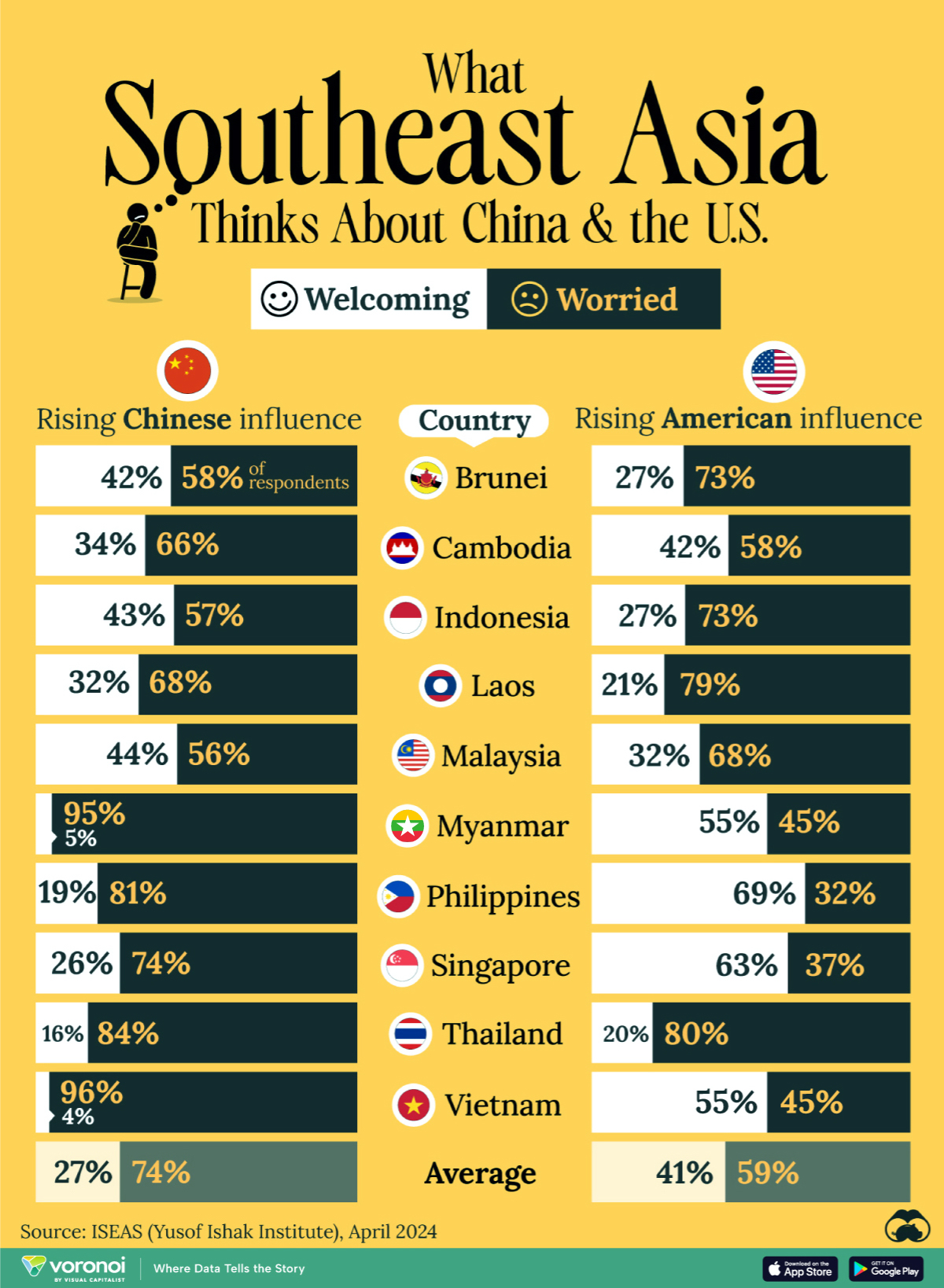
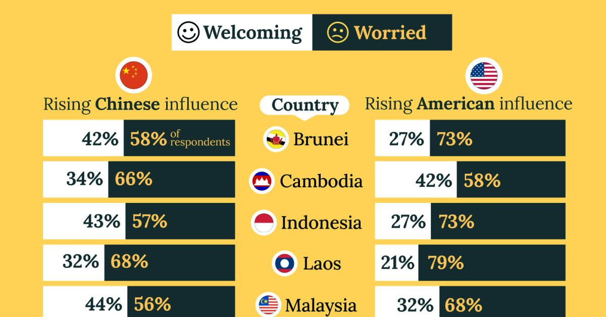
What Southeast Asia Thinks About China & the U.S.
This was originally posted on our Voronoi app. Download the app for free on iOS or Android and discover incredible data-driven charts from a variety of trusted sources.
This chart visualizes the results of a 2024 survey conducted by the ASEAN Studies Centre at the ISEAS-Yusof Ishak Institute. Nearly 2,000 respondents were asked if they were worried or welcoming of rising Chinese and American geopolitical influence in their country.
The countries surveyed all belong to the Association of Southeast Asian Nations (ASEAN), a political and economic union of 10 states in Southeast Asia.
Feelings Towards China
On average, a significant share of respondents from all 10 countries are worried about rising influence from both the U.S. and China.
However, overall skepticism is higher for China, at 74% (versus 59% for U.S.).
| Country | Worried About Growing 🇨🇳 Influence | Welcome Growing 🇨🇳 Influence |
|---|---|---|
| 🇧🇳 Brunei | 58% | 42% |
| 🇰🇭 Cambodia | 66% | 34% |
| 🇮🇩 Indonesia | 57% | 43% |
| 🇱🇦 Laos | 68% | 32% |
| 🇲🇾 Malaysia | 56% | 44% |
| 🇲🇲 Myanmar | 95% | 5% |
| 🇵🇭 Philippines | 81% | 19% |
| 🇸🇬 Singapore | 74% | 26% |
| 🇹🇭 Thailand | 84% | 16% |
| 🇻🇳 Vietnam | 96% | 4% |
| Average | 74% | 27% |
The recently-cooled but still active territorial concerns over the South China Sea may play a significant role in these responses, especially in countries which are also claimants over the sea.
For example, in Vietnam over 95% of respondents said they were worried about China’s growing influence.
Feelings Towards America
Conversely, rising American influence is welcomed in two countries with competing claims in the South China Sea, the Philippines (69%) and Vietnam (55%).
| Country | Worried About Growing 🇺🇸 Influence | Welcome Growing 🇺🇸 Influence |
|---|---|---|
| 🇧🇳 Brunei | 73% | 27% |
| 🇰🇭 Cambodia | 58% | 42% |
| 🇮🇩 Indonesia | 73% | 27% |
| 🇱🇦 Laos | 79% | 21% |
| 🇲🇾 Malaysia | 68% | 32% |
| 🇲🇲 Myanmar | 45% | 55% |
| 🇵🇭 Philippines | 32% | 69% |
| 🇸🇬 Singapore | 37% | 63% |
| 🇹🇭 Thailand | 80% | 20% |
| 🇻🇳 Vietnam | 45% | 55% |
| Average | 59% | 41% |
Despite this, on a regional average, more respondents worry about growing American influence (59%) than they welcome it (41%).
Interestingly, it seems almost every ASEAN nation has a clear preference for one superpower over the other.
The only exception is Thailand, where those surveyed were not a fan of either option, with 84% worried about China, and 80% worried about the U.S.

-

 Culture6 days ago
The World’s Top Media Franchises by All-Time Revenue
-

 Science2 weeks ago
Visualizing the Average Lifespans of Mammals
-

 Brands2 weeks ago
How Tech Logos Have Evolved Over Time
-

 Energy2 weeks ago
Ranked: The Top 10 EV Battery Manufacturers in 2023
-
 Countries2 weeks ago
Countries With the Largest Happiness Gains Since 2010
-

 Economy2 weeks ago
VC+: Get Our Key Takeaways From the IMF’s World Economic Outlook
-

 Demographics2 weeks ago
The Countries That Have Become Sadder Since 2010
-
 Money1 week ago
Charted: Who Has Savings in This Economy?