Misc
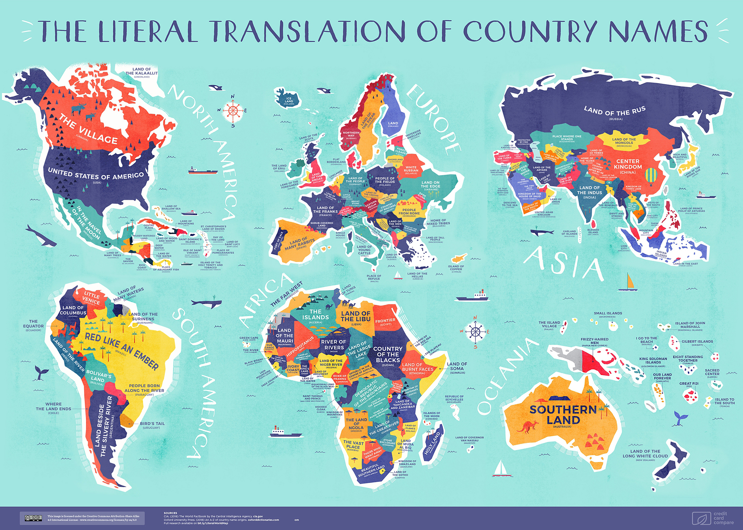
Mapped: The Literal Translation of Every Country’s Name
View the full-size version of the infographic
Mapped: The Literal Translation of Every Country’s Name
View the full-size version of the infographic by clicking here
These days, planes, trains, and automobiles can deliver us to any destination we can name. But how often can we say we know the origins of those names?
Today’s map comes to us courtesy of Credit Card Compare, and it visualizes the literal translations of every country’s name, arranged by continent. Of course, naming conventions are always layered and open to interpretation — especially when they’ve gone through multiple levels of translation — but it’s still an interesting exercise to trace where they are thought to come from.
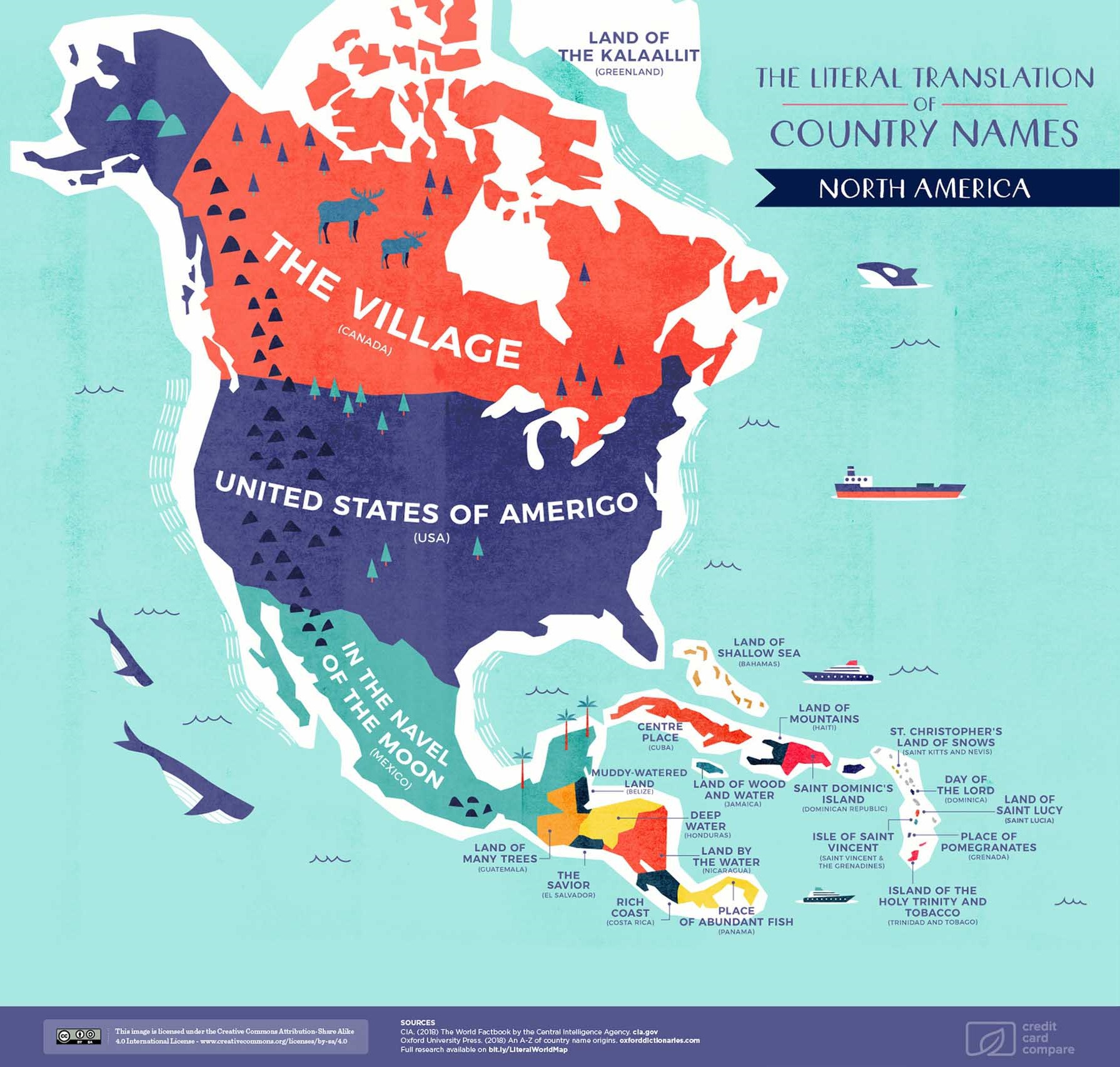
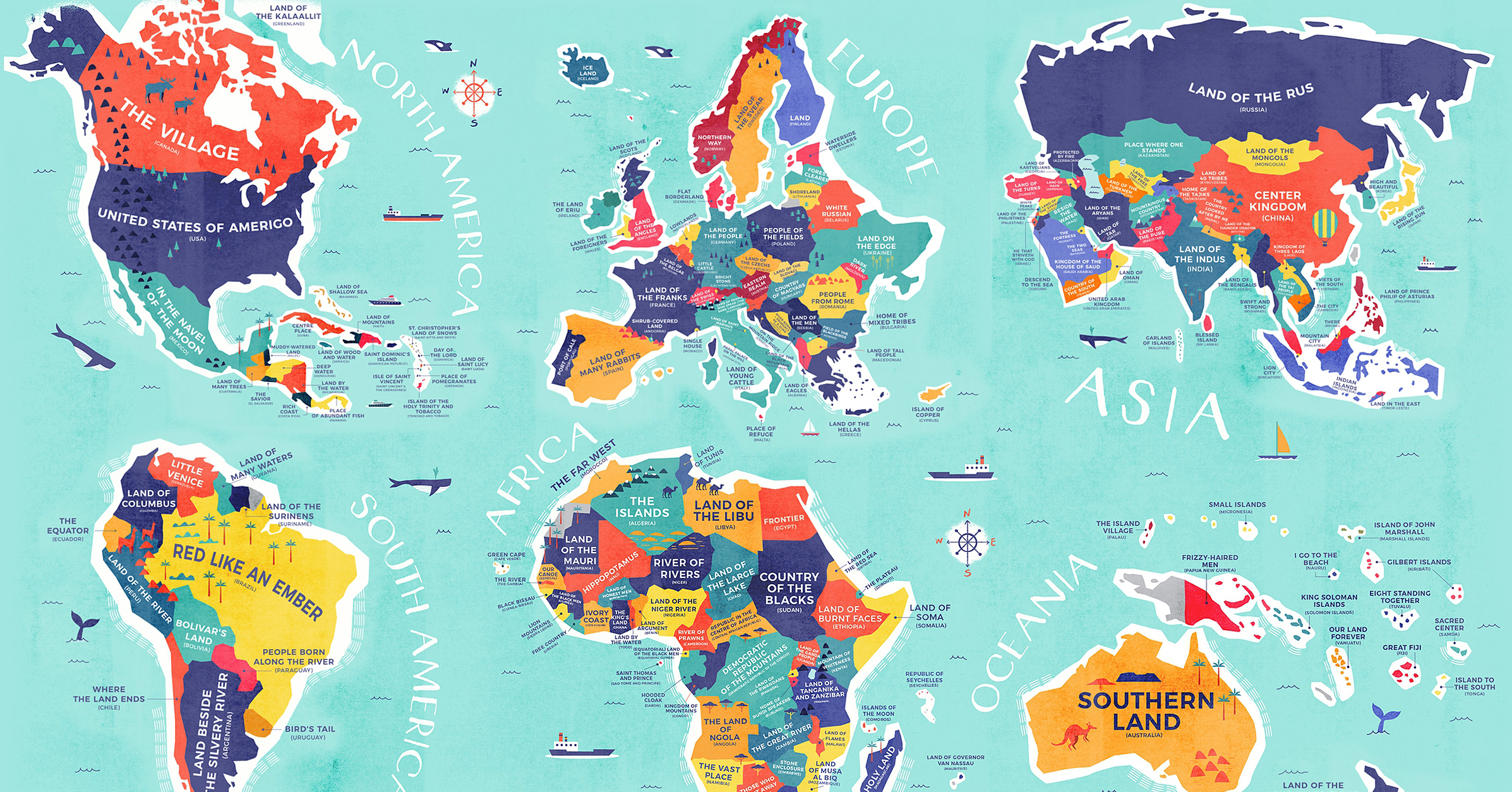
North America
Starting with the Great White North, Canada’s name is derived from the Indigenous Huron people. Kanata means village, or settlement, in the Iroquoian language. Meanwhile, The United States of America was named in honor of the Italian explorer Amerigo Vespucci. Vespucci is credited with correcting Columbus’ error, in which the latter mistook the New World for the East Indies.
Finally, Mexico comes from the simplified Spanish translation for the Aztec capital, Metztlixihtlico, which is said to mean “place at the center of the moon”. The word is a blend of mētztli for ‘moon’, xictli for ‘navel’ or ‘centre’, and the suffix -co for ‘place’.
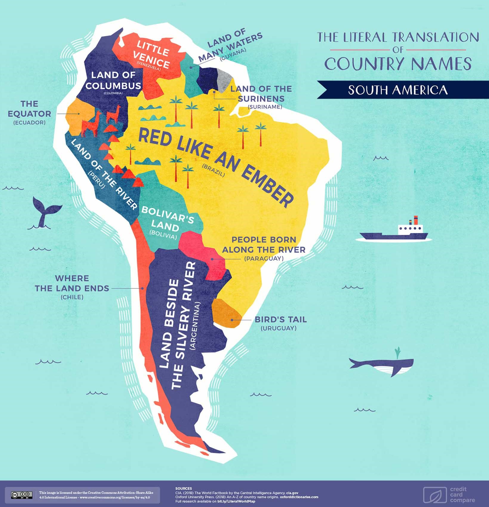
South America
Brazil’s name is actually shortened from Terra do Brasil (land of Brazil). The brazilwood tree, or pau-brasil, was valued highly in the early 16th century. It was used to produce red dyes for the European textile industry — hence the “red like an ember” moniker.
Uruguay has a couple of meanings attached to it, the first being “Bird’s Tail” in reference to the uru, a type of quail that lived by the river. Another association is the uruguä, a species of mussel, for which the country is named “River of Shellfish”. It’s interesting to note the relationship to water and rivers, which is reflected in the similarly-themed naming history across the continent.
Venezuela is named for its resemblance to the Italian city of Venice, thus gaining the title of “Little Venice”. Another area also named after European cities? Colombia, which was originally named “New Granada” in a hat tip to the capital of the Spanish province.
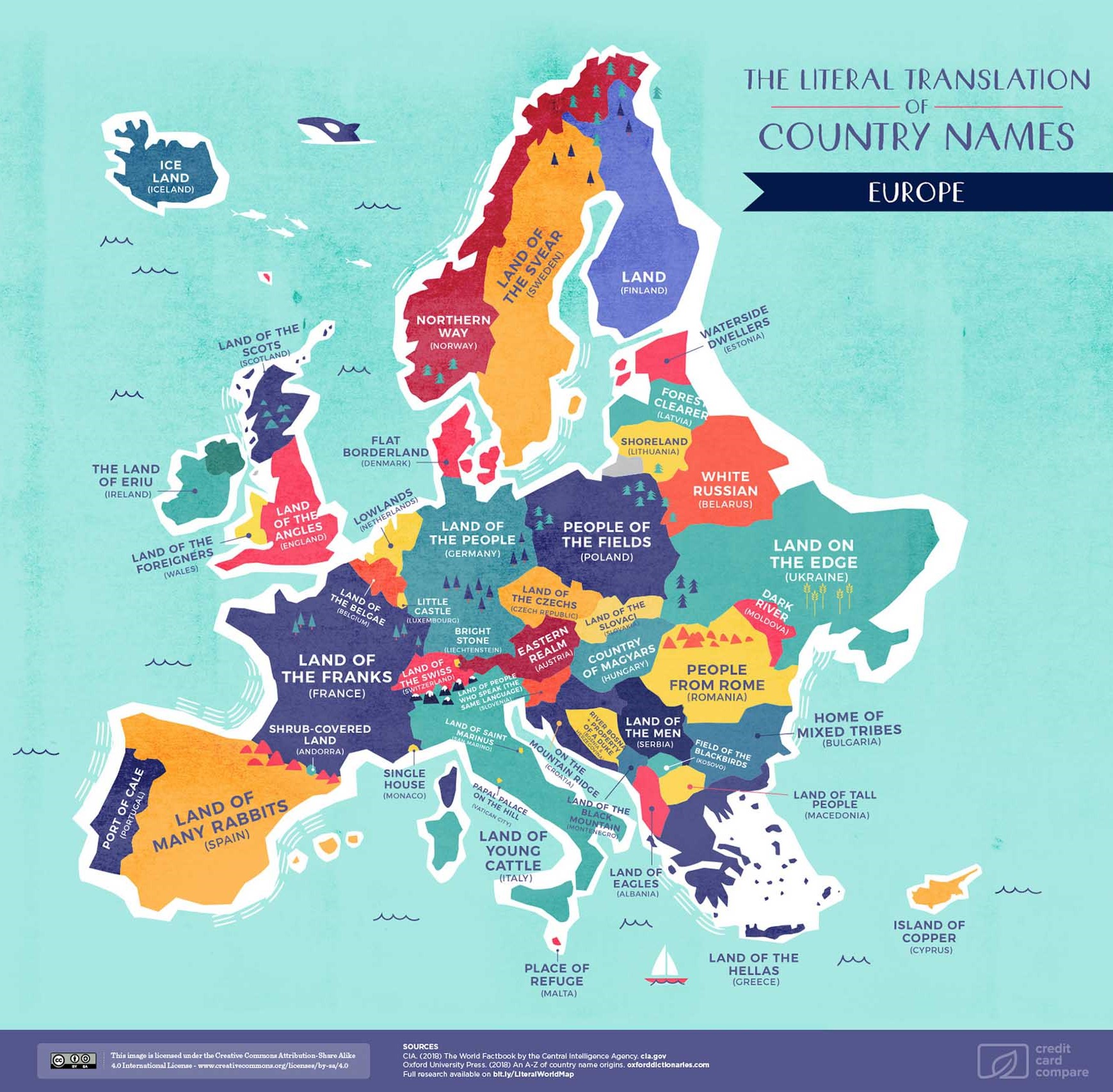
Europe
The “Land of the Franks”, France, gets its namesake from the Latin word francia. This dates back even further to the Old German word franka, meaning brave, or fierce. There’s also a political angle to the name: King Louis V famously proclaimed that “France signifies freedom”.
The exact origin for Germany is unknown, possibly because it was composed of various tribes and states before 1871. It’s known as Deutschland (for “of the people”) in German, Alemania in Spanish, Niemcy in Polish, and Saksa in Finnish. Another theory ties it with the Celtic word ‘gair’ for neighbor.
By the Mediterranean, the boot-shaped country of Italy gets its name from the symbol of the Southern Italic Vitali tribe: the bull. The name is connected to the Latin vitulus for ‘calf’ or ‘sons of the bull’. Another interpretation is the phrase diovi-telia, which translates to “land of the light”.
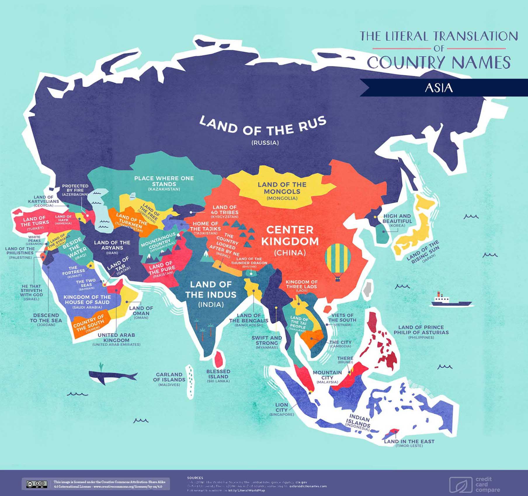
Asia
China’s English name comes from the Qin dynasty, the first unified and multinational state in Chinese history. Although the dynasty only existed between 221-207 BC, it had a profound and lasting influence on the country. A fascinating tidbit is that China’s name in fact borrows from the Persian language, and even Sanskrit.
India’s name comes from Greek, but also the Sanskrit Síndhu, where both refer to the Indus River. Bharat is another official and historically significant name for the Republic of India, and Hindustan is an alternative name for the region, but its use depends on context and language.
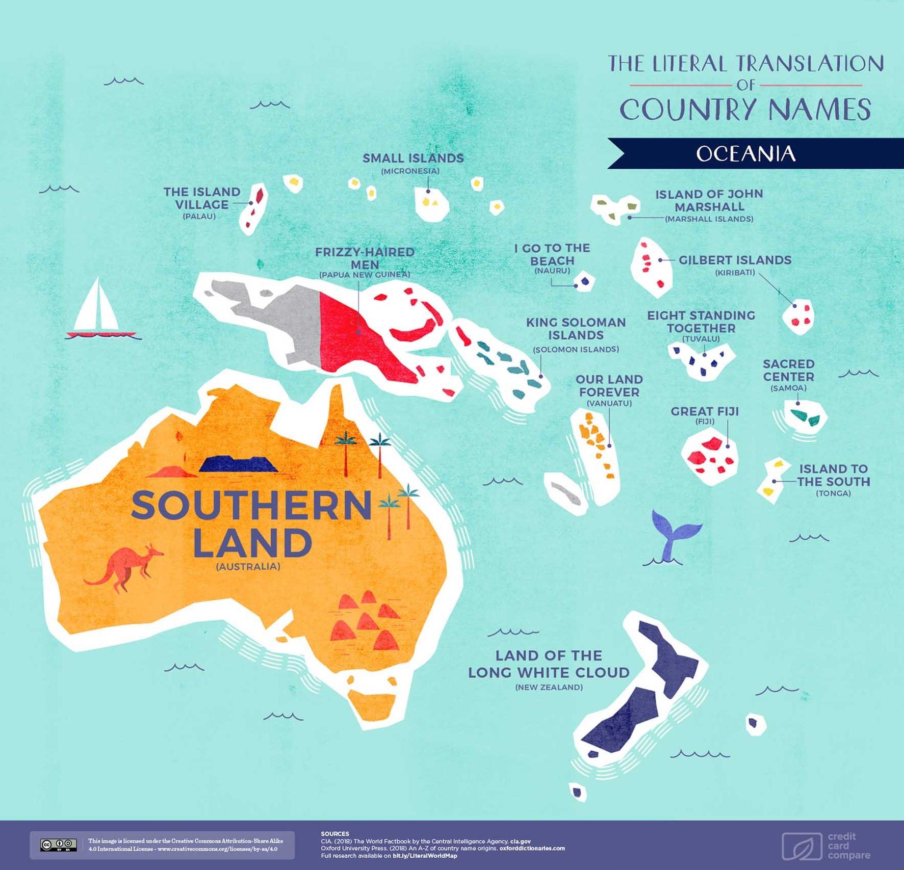
Oceania
The Land Down Under of Australia is fairly geographical in its name, drawn from the Latin australis for “southern”. The explorer Matthew Flinders popularized the name as we know it in 1804, and “Australia” replaced “New Holland” as the official continent.
The Māori name for New Zealand is Aotearoa, which is most commonly defined as “the long white cloud” — a reference to early Polynesian navigators discovering the country by relying on cloud formations.
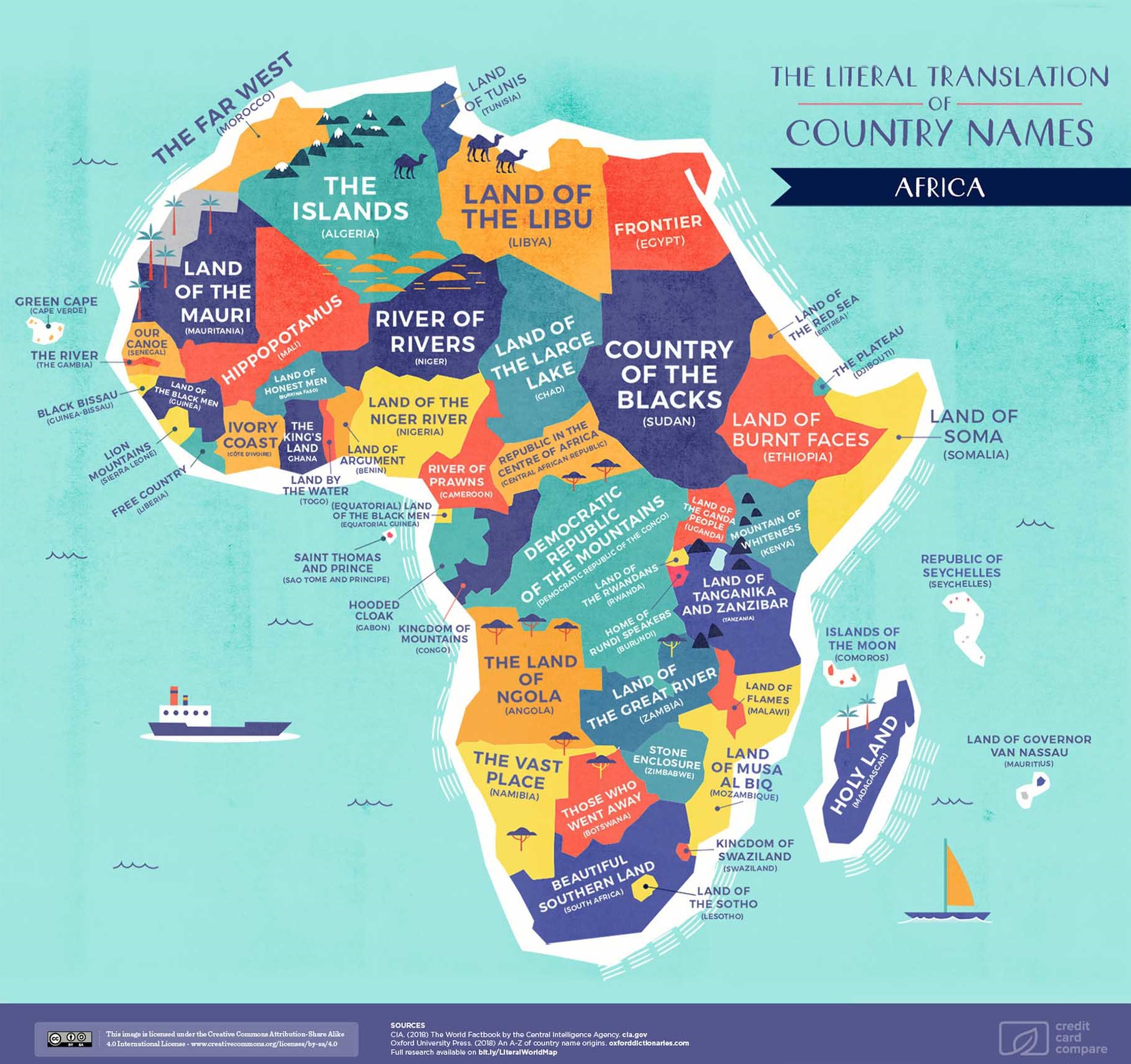
Africa
The name Egypt comes from the Ancient Greek Aiguptos and Latin Ægyptus, and is also derived from hūt-kā-ptah (Temple of the Soul of Ptah). The ancient Egyptian name for the country was km.t (pronounced “kemet”), meaning “black land” likely for the fertile soils of the Nile valley. Today, Egypt’s official name is Jumhūrīyat Miṣr al-ʻArabīyah, or “Arab Republic of Egypt”.
South Africa is aptly named for its geographical location. Interestingly, however, the country has different names in the country’s 11 official languages, including English, Afrikaans, the Venda language, the Tsonga language, and the Nguni and Sotho languages.
What rich histories can be uncovered from your country’s name?
Note: Where some of the country names on the individual maps vary from the translations, please consult the original research document which include the English translations and explanations behind the etymology.


VC+
VC+: Get Our Key Takeaways From the IMF’s World Economic Outlook
A sneak preview of the exclusive VC+ Special Dispatch—your shortcut to understanding IMF’s World Economic Outlook report.

Have you read IMF’s latest World Economic Outlook yet? At a daunting 202 pages, we don’t blame you if it’s still on your to-do list.
But don’t worry, you don’t need to read the whole April release, because we’ve already done the hard work for you.
To save you time and effort, the Visual Capitalist team has compiled a visual analysis of everything you need to know from the report—and our VC+ Special Dispatch is available exclusively to VC+ members. All you need to do is log into the VC+ Archive.
If you’re not already subscribed to VC+, make sure you sign up now to access the full analysis of the IMF report, and more (we release similar deep dives every week).
For now, here’s what VC+ members get to see.
Your Shortcut to Understanding IMF’s World Economic Outlook
With long and short-term growth prospects declining for many countries around the world, this Special Dispatch offers a visual analysis of the key figures and takeaways from the IMF’s report including:
- The global decline in economic growth forecasts
- Real GDP growth and inflation forecasts for major nations in 2024
- When interest rate cuts will happen and interest rate forecasts
- How debt-to-GDP ratios have changed since 2000
- And much more!

Get the Full Breakdown in the Next VC+ Special Dispatch
VC+ members can access the full Special Dispatch by logging into the VC+ Archive, where you can also check out previous releases.
Make sure you join VC+ now to see exclusive charts and the full analysis of key takeaways from IMF’s World Economic Outlook.
Don’t miss out. Become a VC+ member today.
What You Get When You Become a VC+ Member
VC+ is Visual Capitalist’s premium subscription. As a member, you’ll get the following:
- Special Dispatches: Deep dive visual briefings on crucial reports and global trends
- Markets This Month: A snappy summary of the state of the markets and what to look out for
- The Trendline: Weekly curation of the best visualizations from across the globe
- Global Forecast Series: Our flagship annual report that covers everything you need to know related to the economy, markets, geopolitics, and the latest tech trends
- VC+ Archive: Hundreds of previously released VC+ briefings and reports that you’ve been missing out on, all in one dedicated hub
You can get all of the above, and more, by joining VC+ today.

-

 Mining1 week ago
Gold vs. S&P 500: Which Has Grown More Over Five Years?
-

 Markets2 weeks ago
Ranked: The Most Valuable Housing Markets in America
-

 Money2 weeks ago
Which States Have the Highest Minimum Wage in America?
-

 AI2 weeks ago
Ranked: Semiconductor Companies by Industry Revenue Share
-

 Markets2 weeks ago
Ranked: The World’s Top Flight Routes, by Revenue
-

 Countries2 weeks ago
Population Projections: The World’s 6 Largest Countries in 2075
-

 Markets2 weeks ago
The Top 10 States by Real GDP Growth in 2023
-

 Demographics2 weeks ago
The Smallest Gender Wage Gaps in OECD Countries