Maps
The Venezuela–Guyana Dispute Explained in 3 Maps
In a territorial dispute spanning nearly two centuries, tensions between Guyana and Venezuela have once again reached a boiling point. The focal point of this dispute is the vast Essequibo region which encompasses around 70% of Guyana’s territory, and is roughly equivalent to the size of Florida.
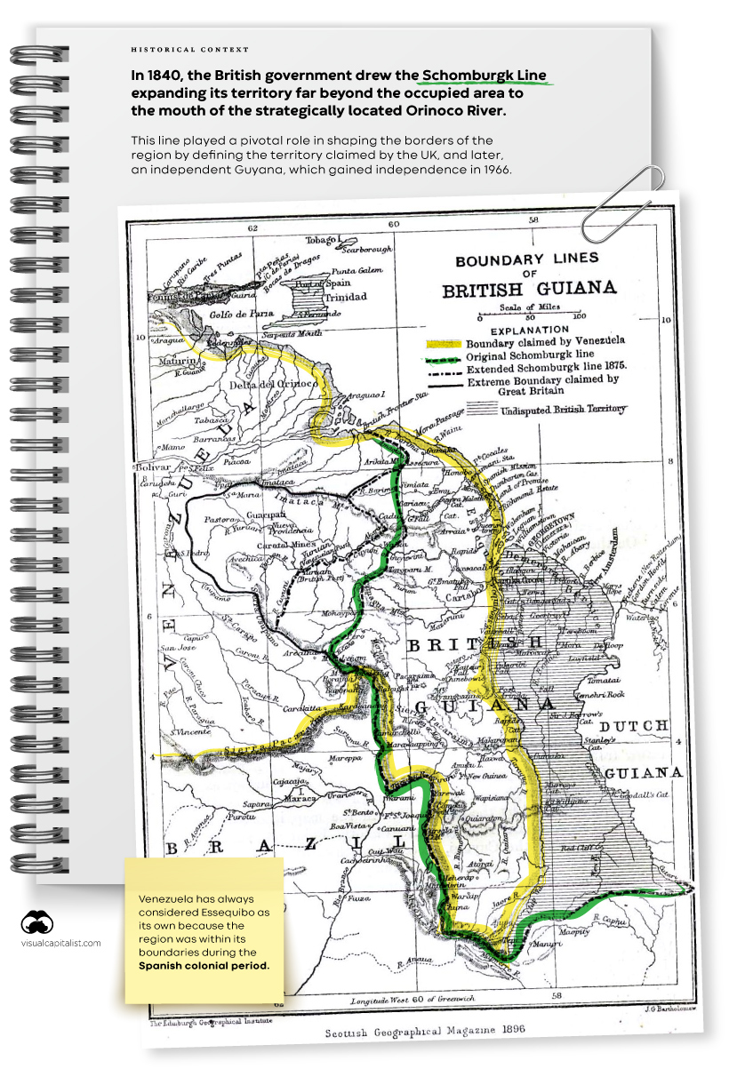
Venezuela claims historical rights dating back to the Spanish colonial period when Essequibo fell within its boundaries. In 1840, the British government drew the Schomburgk Line expanding the territory of British Guiana (now Guyana) far beyond the occupied area and to the strategically-located mouth of the Orinoco River.
Click to enlarge
This line played a pivotal role in shaping the modern borders of the region by defining the territory claimed by the UK, and later, a decolonized Guyana, as the country gained independence in 1966. That same year, Venezuela and the UK signed an agreement aiming for a negotiated solution.
In 2004, President Hugo Chávez eased border tensions under the advice of Fidel Castro, stating that he considered the dispute to be finished.
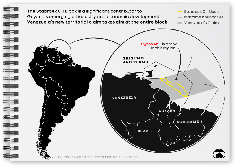
Recent events, however, have reignited the dispute. Between 2015 and 2021, Guyana announced the discovery of about 8 billion barrels of oil, elevating a country with fewer than a million people to a prominent position among the top nations in terms of oil reserves. ExxonMobil, leading a consortium, operates three offshore projects in the country, earning nearly $6 billion in 2022 alone.
Venezuela’s Referendum and New Map
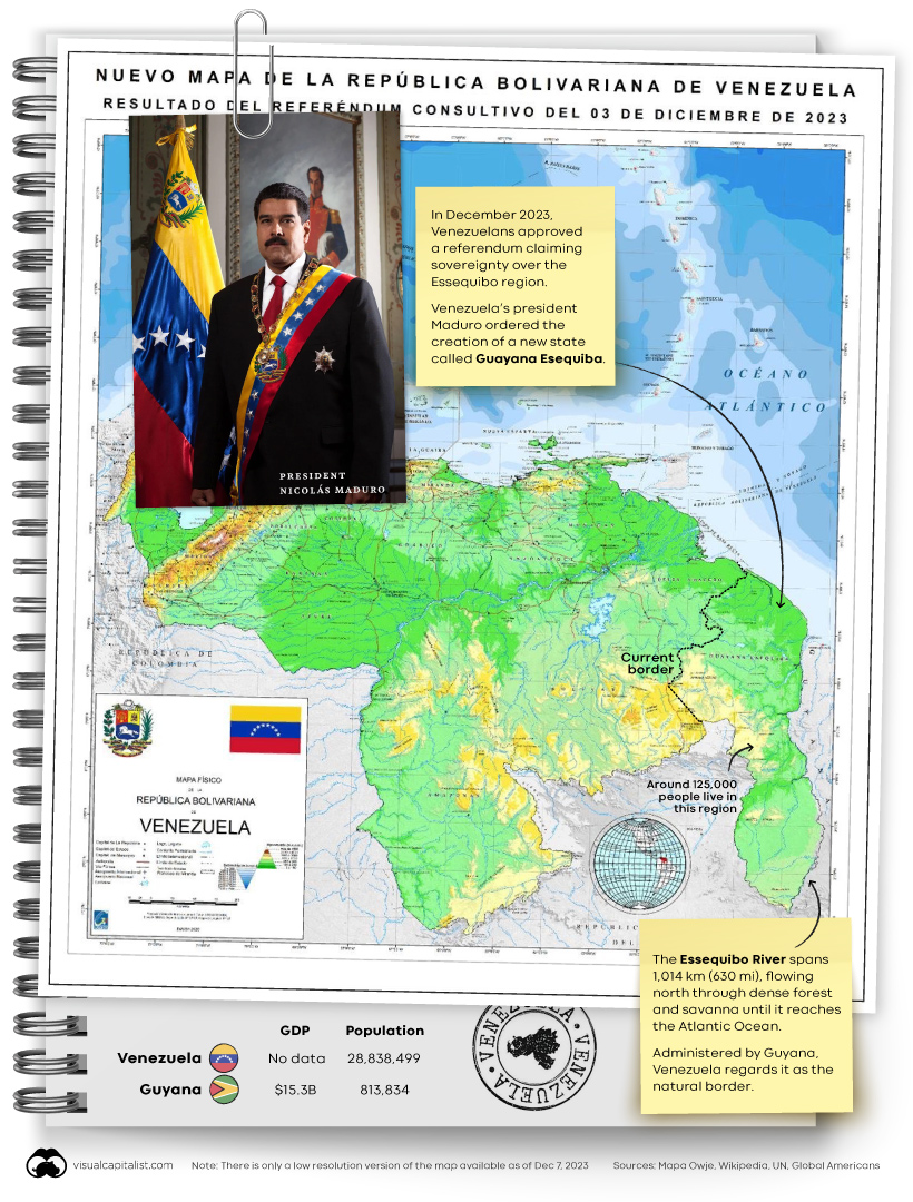
On December 1, 2023, the World Court ordered Venezuela to refrain from actions in the border dispute with Guyana. However, just two days later, on December 3, Venezuelans approved a referendum claiming sovereignty over Essequibo.
Click to enlarge
President Maduro subsequently ordered the creation of a new state, Guayana Esequiba, within Venezuela’s borders, and released a new map of the country.
Venezuela’s new territorial claims don’t stop on land, they extend far out into sea as well. Specifically, Venezuela is claiming a critical area called the Stabroek Oil Block, where ExxonMobil and others are already active.
With a population of around 125,000 people, the disputed region is full of dense rainforest, making a military incursion from Venezuela feasible only by sea or through the Brazilian state of Roraima. Brazil, maintaining good diplomatic relationships with both countries, has already increased military personnel on the border. The U.S. announced joint military flight drills in Guyana on December 7.
Despite increased military presence in the region, many experts believe that President Maduro has no intention of actually annexing Essequibo, and that this recent claim is a tactic to bolster his own image within Venezuela.


Maps
The Largest Earthquakes in the New York Area (1970-2024)
The earthquake that shook buildings across New York in April 2024 was the third-largest quake in the Northeast U.S. over the past 50 years.


The Largest Earthquakes in the New York Area
This was originally posted on our Voronoi app. Download the app for free on Apple or Android and discover incredible data-driven charts from a variety of trusted sources.
The 4.8 magnitude earthquake that shook buildings across New York on Friday, April 5th, 2024 was the third-largest quake in the U.S. Northeast area over the past 50 years.
In this map, we illustrate earthquakes with a magnitude of 4.0 or greater recorded in the Northeastern U.S. since 1970, according to the United States Geological Survey (USGS).
Shallow Quakes and Older Buildings
The earthquake that struck the U.S. Northeast in April 2024 was felt by millions of people from Washington, D.C., to north of Boston. It even caused a full ground stop at Newark Airport.
The quake, occurring just 5 km beneath the Earth’s surface, was considered shallow, which is what contributed to more intense shaking at the surface.
According to the USGS, rocks in the eastern U.S. are significantly older, denser, and harder than those on the western side, compressed by time. This makes them more efficient conduits for seismic energy. Additionally, buildings in the Northeast tend to be older and may not adhere to the latest earthquake codes.
Despite disrupting work and school life, the earthquake was considered minor, according to the Michigan Technological University magnitude scale:
| Magnitude | Earthquake Effects | Estimated Number Each Year |
|---|---|---|
| 2.5 or less | Usually not felt, but can be recorded by seismograph. | Millions |
| 2.5 to 5.4 | Often felt, but only causes minor damage. | 500,000 |
| 5.5 to 6.0 | Slight damage to buildings and other structures. | 350 |
| 6.1 to 6.9 | May cause a lot of damage in very populated areas. | 100 |
| 7.0 to 7.9 | Major earthquake. Serious damage. | 10-15 |
| 8.0 or greater | Great earthquake. Can totally destroy communities near the epicenter. | One every year or two |
The largest earthquake felt in the area over the past 50 years was a 5.3 magnitude quake that occurred in Au Sable Forks, New York, in 2002. It damaged houses and cracked roads in a remote corner of the Adirondack Mountains, but caused no injuries.
| Date | Magnitude | Location | State |
|---|---|---|---|
| April 20, 2002 | 5.3 | Au Sable Forks | New York |
| October 7, 1983 | 5.1 | Newcomb | New York |
| April 5, 2024 | 4.8 | Whitehouse Station | New Jersey |
| October 16, 2012 | 4.7 | Hollis Center | Maine |
| January 16, 1994 | 4.6 | Sinking Spring | Pennsylvania |
| January 19, 1982 | 4.5 | Sanbornton | New Hampshire |
| September 25, 1998 | 4.5 | Adamsville | Pennsylvania |
| June 9, 1975 | 4.2 | Altona | New York |
| May 29, 1983 | 4.2 | Peru | Maine |
| April 23, 1984 | 4.2 | Conestoga | Pennsylvania |
| January 16, 1994 | 4.2 | Sinking Spring | Pennsylvania |
| November 3, 1975 | 4 | Long Lake | New York |
| June 17, 1991 | 4 | Worcester | New York |
The largest earthquake in U.S. history, however, was the 1964 Good Friday quake in Alaska, measuring 9.2 magnitude and killing 131 people.

-

 Debt1 week ago
How Debt-to-GDP Ratios Have Changed Since 2000
-

 Countries2 weeks ago
Population Projections: The World’s 6 Largest Countries in 2075
-

 Markets2 weeks ago
The Top 10 States by Real GDP Growth in 2023
-

 Demographics2 weeks ago
The Smallest Gender Wage Gaps in OECD Countries
-

 United States2 weeks ago
Where U.S. Inflation Hit the Hardest in March 2024
-

 Green2 weeks ago
Top Countries By Forest Growth Since 2001
-

 United States2 weeks ago
Ranked: The Largest U.S. Corporations by Number of Employees
-

 Maps2 weeks ago
The Largest Earthquakes in the New York Area (1970-2024)