Maps
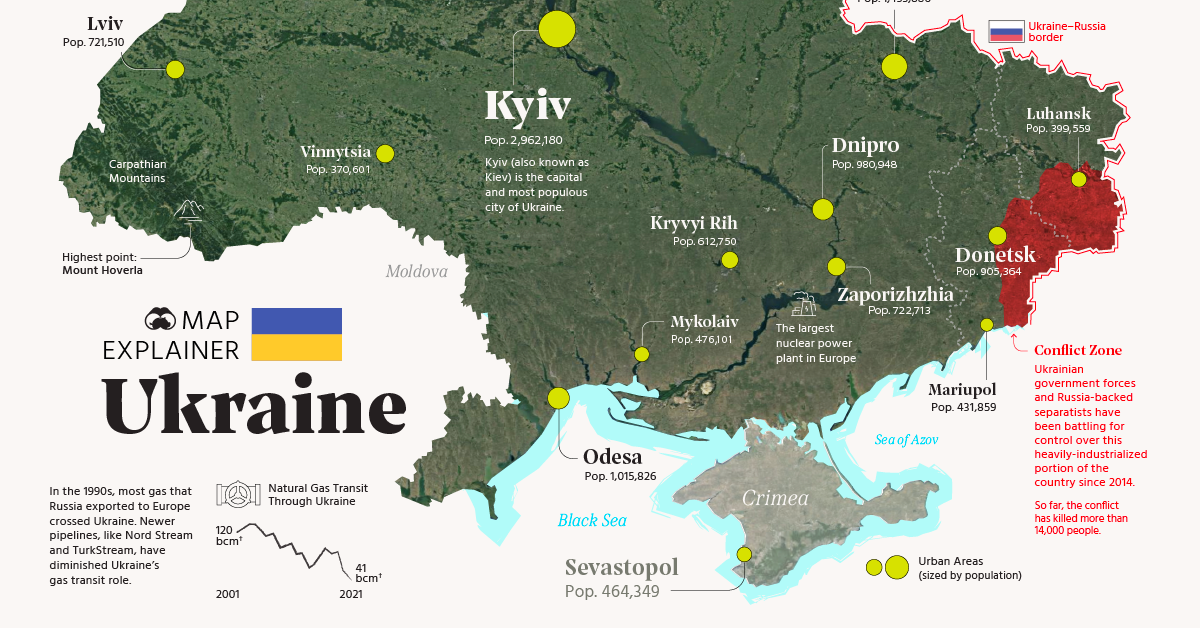
Map Explainer: Key Facts About Ukraine
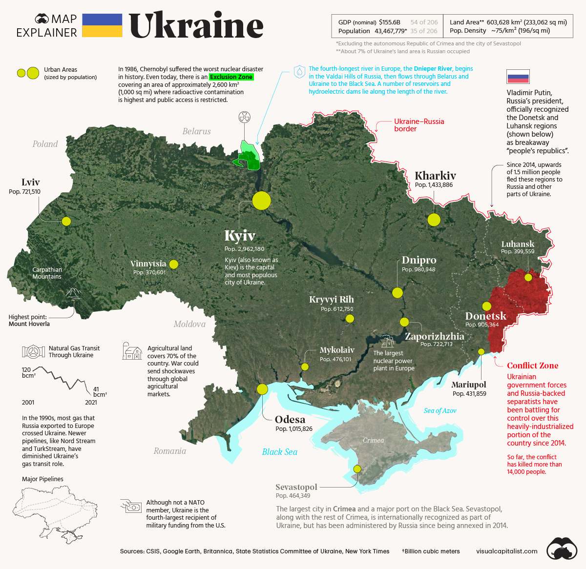


Map Explainer: Key Facts About Ukraine
The modern state of Ukraine was formed nearly 30 years ago after the collapse of the Soviet Union in 1991. Since then, the country has often made headlines due to political instability and the looming threat of a Russian invasion.
In the map graphic above, we examine Ukraine from a structural point of view. What’s the country’s population composition? What drives the country’s economy? And most importantly, why is the country important within a global context?
Where Do People Live in Ukraine?
With a population of nearly 44 million people, Ukraine is the eighth-most populous country in Europe. For perspective, that is slightly smaller than Spain, and four times larger than Greece.
As the cartogram below demonstrates, a large portion of the country’s population is located in and around the capital Kyiv, along with the Donetsk region—which is front and center in the current conflict with Russia.
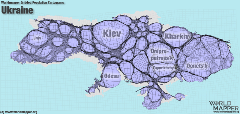
Not surprisingly, many of the country’s Russian speaking citizens live on the eastern side of the country, near the Russian border.
Key Facts About Ukraine’s Demographics
Ukrainians make up almost 78% of the total population, while Russians represent around 17% of the population, making it the single-largest Russian diaspora in the world.
Other minorities include:
- Belarusians: 0.6%
- Bulgarians: 0.4%
- Hungarians: 0.3%
- Crimean Tatars: 0.5%
- Romanians: 0.3%
- Poles: 0.3%
- Jews: 0.2%
The country’s population has been declining since the 1990s because of a high emigration rate, and high death rates coupled with a low birth rate.
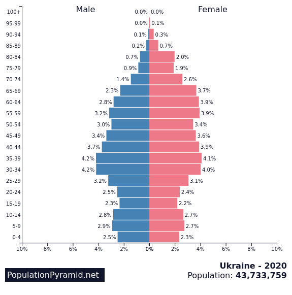
Source: Population Pyramid
The majority of the population is Christian (80%), with 60% declaring adherence to one or another strand of the Orthodox Church.
Ukraine’s Economy: An Overview
When the Soviet Union collapsed, Ukraine turned over thousands of atomic weapons in exchange for security guarantees from Russia, the United States, and other countries. However, the defense industry continues to be a strategically important sector and a large employer in Ukraine. The country exports weapons to countries like India, Saudi Arabia, and Turkey.
Furthermore, Ukraine is rich in natural resources, particularly in mineral deposits. It possesses the world’s largest reserves of commercial-grade iron ore—30 billion tonnes of ore or around one-fifth of the global total. It’s also worth noting that Ukraine ranks second in terms of known natural gas reserves in Europe, which today remain largely untapped.
Ukraine’s mostly flat geography and high-quality soil composition make the country a big regional agricultural player. The country is the world’s fifth-largest exporter of wheat and the world’s largest exporter of seed oils like sunflower and rapeseed.
Coal mining, chemicals, mechanical products (aircraft, turbines, locomotives and tractors) and shipbuilding are also important sectors of the Ukrainian economy.
The Bear in the Room
Given the country’s location and history, it’s nearly impossible to talk about Ukraine without mentioning nearby Russia.
The country shares borders with Russia both to the east and northeast. For context, a car trip from Moscow to one of the Ukrainian border cities, Shostka, takes around 8 hours. To the Northwest, Ukraine also shares borders with Belarus—a country that is closely aligned with the Kremlin.
To the southeast is Crimea, a peninsula entirely surrounded by both the Black Sea and the smaller Sea of Azov. In 2014, Russia annexed the peninsula and established two federal subjects, the Republic of Crimea and the federal city of Sevastopol. The annexation was widely condemned around the world, and the territories are recognized by most of the international community as being part of Ukraine.
The region was of particular interest to Russia since Moscow depends on the Black Sea for access to the Mediterranean. The Port of Sevastopol, on the southwest edge of Crimea, is one of the few ice-free deepwater ports available to Russia in the region.
Due to ongoing tensions between the two countries, Ukraine has been seeking to reduce Russia’s leverage over its economy. As a result, China and Poland have surpassed Russia as Ukraine’s largest country trading partners in recent years.
However, Ukraine still remains an important route for Russian gas that heats millions of homes, generates electricity, and powers factories in Europe. The continent gets nearly 40% of its natural gas and 25% of its oil from Russia.
Furthermore, Ukraine is connected to the same power grid as Russia, so it remains dependent on Moscow in the event of a shortfall. Even as conflict heats up, the two countries still share economic links, which will influence how the situation unfolds.
Conflict in the Donbas Region
Ukraine stands at the center of a geopolitical rivalry between western powers and Russia, and that rivalry is flaring up once again.
Two regions along the Russian border—Donetsk and Luhansk—have been a conflict zone since 2014, when pro-Russian separatists began clashing with government forces. The map below shows the relative contact zone between the two opposing forces.
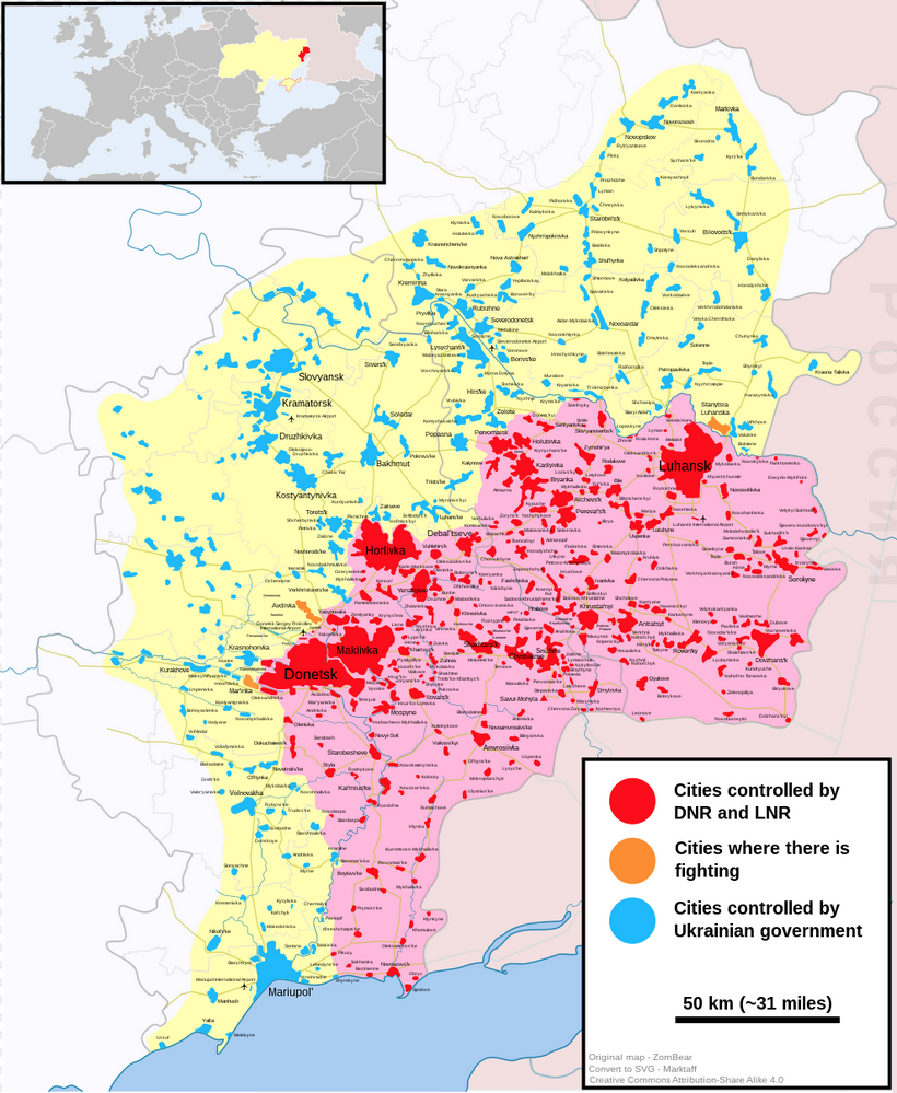
ZomBear, Marktaff, CC BY-SA 4.0 , via Wikimedia Commons
Currently Russia has troops and military equipment amassed at various points along the border between the two countries, as well as in neighboring Belarus.
In recent days, Russian President Vladimir Putin ordered troops into two breakaway regions in eastern Ukraine, recognizing them as independent states. This recognition serves as a definitive end point to the seven-year peace deal known as the Minsk agreement.
As this conflict heats up, it remains to be seen what will happen to the roughly 5 million people who live in the Donbas region.
Note: As of February 23rd, 2022, Russia launched a full-scale military operation into Ukraine. The situation is still evolving rapidly.


Maps
The Largest Earthquakes in the New York Area (1970-2024)
The earthquake that shook buildings across New York in April 2024 was the third-largest quake in the Northeast U.S. over the past 50 years.


The Largest Earthquakes in the New York Area
This was originally posted on our Voronoi app. Download the app for free on Apple or Android and discover incredible data-driven charts from a variety of trusted sources.
The 4.8 magnitude earthquake that shook buildings across New York on Friday, April 5th, 2024 was the third-largest quake in the U.S. Northeast area over the past 50 years.
In this map, we illustrate earthquakes with a magnitude of 4.0 or greater recorded in the Northeastern U.S. since 1970, according to the United States Geological Survey (USGS).
Shallow Quakes and Older Buildings
The earthquake that struck the U.S. Northeast in April 2024 was felt by millions of people from Washington, D.C., to north of Boston. It even caused a full ground stop at Newark Airport.
The quake, occurring just 5 km beneath the Earth’s surface, was considered shallow, which is what contributed to more intense shaking at the surface.
According to the USGS, rocks in the eastern U.S. are significantly older, denser, and harder than those on the western side, compressed by time. This makes them more efficient conduits for seismic energy. Additionally, buildings in the Northeast tend to be older and may not adhere to the latest earthquake codes.
Despite disrupting work and school life, the earthquake was considered minor, according to the Michigan Technological University magnitude scale:
| Magnitude | Earthquake Effects | Estimated Number Each Year |
|---|---|---|
| 2.5 or less | Usually not felt, but can be recorded by seismograph. | Millions |
| 2.5 to 5.4 | Often felt, but only causes minor damage. | 500,000 |
| 5.5 to 6.0 | Slight damage to buildings and other structures. | 350 |
| 6.1 to 6.9 | May cause a lot of damage in very populated areas. | 100 |
| 7.0 to 7.9 | Major earthquake. Serious damage. | 10-15 |
| 8.0 or greater | Great earthquake. Can totally destroy communities near the epicenter. | One every year or two |
The largest earthquake felt in the area over the past 50 years was a 5.3 magnitude quake that occurred in Au Sable Forks, New York, in 2002. It damaged houses and cracked roads in a remote corner of the Adirondack Mountains, but caused no injuries.
| Date | Magnitude | Location | State |
|---|---|---|---|
| April 20, 2002 | 5.3 | Au Sable Forks | New York |
| October 7, 1983 | 5.1 | Newcomb | New York |
| April 5, 2024 | 4.8 | Whitehouse Station | New Jersey |
| October 16, 2012 | 4.7 | Hollis Center | Maine |
| January 16, 1994 | 4.6 | Sinking Spring | Pennsylvania |
| January 19, 1982 | 4.5 | Sanbornton | New Hampshire |
| September 25, 1998 | 4.5 | Adamsville | Pennsylvania |
| June 9, 1975 | 4.2 | Altona | New York |
| May 29, 1983 | 4.2 | Peru | Maine |
| April 23, 1984 | 4.2 | Conestoga | Pennsylvania |
| January 16, 1994 | 4.2 | Sinking Spring | Pennsylvania |
| November 3, 1975 | 4 | Long Lake | New York |
| June 17, 1991 | 4 | Worcester | New York |
The largest earthquake in U.S. history, however, was the 1964 Good Friday quake in Alaska, measuring 9.2 magnitude and killing 131 people.

-

 Markets1 week ago
U.S. Debt Interest Payments Reach $1 Trillion
-

 Business2 weeks ago
Charted: Big Four Market Share by S&P 500 Audits
-

 Real Estate2 weeks ago
Ranked: The Most Valuable Housing Markets in America
-

 Money2 weeks ago
Which States Have the Highest Minimum Wage in America?
-

 AI2 weeks ago
Ranked: Semiconductor Companies by Industry Revenue Share
-

 Markets2 weeks ago
Ranked: The World’s Top Flight Routes, by Revenue
-

 Demographics2 weeks ago
Population Projections: The World’s 6 Largest Countries in 2075
-

 Markets2 weeks ago
The Top 10 States by Real GDP Growth in 2023