Maps
Mapped: The Ukraine Refugee Crisis in Europe
Article/Editing:
Mapped: The Ukraine Refugee Crisis in Europe
The world has seen several refugee crises over the last decade, from conflicts in the Americas, the Middle East, Africa, and Asia. However, over the last few months, another migrant crisis has emerged, and once again Europe has been the focus.
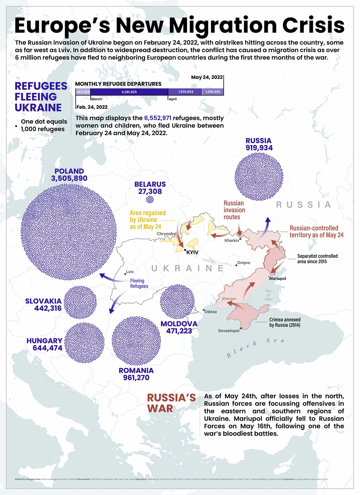
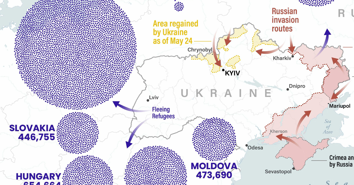
On February 24, 2022, Russia launched a full-scale military invasion of Ukraine. Since then, millions of Ukrainians have fled their homes in search of refuge, with a majority heading through neighboring countries like Poland, Romania, and Russia.
This map by Elbie Bentley uses immigration data from the UN Refugee Agency (UNHCR) as of May 24th, 2022 to visualize current migration crisis that’s happening across Europe. It shows where Ukrainian refugees crossed borders as they fled the conflict.
Refugee Border Crossings into Neighboring Countries
Since Russia’s invasion of Ukraine, close to 6.6 million people have fled Ukraine to neighboring countries. Put another way, this is the largest refugee crisis in Europe since WWII.
| Country | # of Border Crossings (as May 24, 2022) |
|---|---|
| 🇵🇱 Poland | 3,505,890 |
| 🇷🇴 Romania | 961,270 |
| 🇷🇺 Russia | 919,934 |
| 🇭🇺 Hungary | 644,474 |
| 🇲🇩 Moldova | 471,223 |
| 🇸🇰 Slovakia | 442,316 |
| 🇧🇾 Belarus | 27,308 |
Data above is from Feb 24 to May 24, 2022. The situation is fluid, and we recommend visiting the data source linked above for the latest data.
Though the UNHCR tracks departures individually, it’s important to note that arrivals can include people who’ve crossed multiple borders after leaving Ukraine. For example, a refugee heading to Romania via Moldova may be counted twice in the dataset. For this reason, adding the individual country totals together results in a number higher than 6.6 million.
Poland has seen the highest number of Ukrainian refugees, with an estimated 3.5 million people crossing the border since February 24th. About a million of those refugees have been registered in Poland, and 94% of those registered refugees have been women and children.
Russia has received the third most refugees, with many of them coming from or near separatist regions in the east of Ukraine. Russia also says it helped evacuate 140,000 civilians from Mariupol, but claims that those populations were not forced to migrate to Russia.
Hungary has seen the fourth-largest influx of refugees, seeing 644,474 Ukrainians cross into the country since the start of the conflict. In recent years, the Hungarian government been in the headlines because of its views towards migrants, including in 2018, when Hungary’s Prime Minister Viktor Orbán made controversial comments about Syrian refugees.
While the above countries are the entry points for refugees, it’s worth noting that many migrants ultimately make their way to many other places throughout Europe and the world. For example, Germany has accepted 780,000 Ukrainian refugees since the start of the war, despite not sharing a border directly with Ukraine.
An Internal Refugee Crisis
While many Ukrainians had fled the country, millions more have been displaced or trapped within.
As of the end of May, approximately 8 million Ukrainians have been forced to relocate, while approximately 13 million are either stranded in areas affected by the conflict or trapped because of things like increased security or infrastructure damage.
Ukraine and Russia are reeling from the war and its impact, and a ripple effect is hitting countries dependent on Ukrainian trade for agricultural and industrial goods and Russian oil and gas. Add the migrant crisis to the mix, and the total consequences will be felt for decades throughout the region.

This article was published as a part of Visual Capitalist's Creator Program, which features data-driven visuals from some of our favorite Creators around the world.


Maps
The Largest Earthquakes in the New York Area (1970-2024)
The earthquake that shook buildings across New York in April 2024 was the third-largest quake in the Northeast U.S. over the past 50 years.


The Largest Earthquakes in the New York Area
This was originally posted on our Voronoi app. Download the app for free on Apple or Android and discover incredible data-driven charts from a variety of trusted sources.
The 4.8 magnitude earthquake that shook buildings across New York on Friday, April 5th, 2024 was the third-largest quake in the U.S. Northeast area over the past 50 years.
In this map, we illustrate earthquakes with a magnitude of 4.0 or greater recorded in the Northeastern U.S. since 1970, according to the United States Geological Survey (USGS).
Shallow Quakes and Older Buildings
The earthquake that struck the U.S. Northeast in April 2024 was felt by millions of people from Washington, D.C., to north of Boston. It even caused a full ground stop at Newark Airport.
The quake, occurring just 5 km beneath the Earth’s surface, was considered shallow, which is what contributed to more intense shaking at the surface.
According to the USGS, rocks in the eastern U.S. are significantly older, denser, and harder than those on the western side, compressed by time. This makes them more efficient conduits for seismic energy. Additionally, buildings in the Northeast tend to be older and may not adhere to the latest earthquake codes.
Despite disrupting work and school life, the earthquake was considered minor, according to the Michigan Technological University magnitude scale:
| Magnitude | Earthquake Effects | Estimated Number Each Year |
|---|---|---|
| 2.5 or less | Usually not felt, but can be recorded by seismograph. | Millions |
| 2.5 to 5.4 | Often felt, but only causes minor damage. | 500,000 |
| 5.5 to 6.0 | Slight damage to buildings and other structures. | 350 |
| 6.1 to 6.9 | May cause a lot of damage in very populated areas. | 100 |
| 7.0 to 7.9 | Major earthquake. Serious damage. | 10-15 |
| 8.0 or greater | Great earthquake. Can totally destroy communities near the epicenter. | One every year or two |
The largest earthquake felt in the area over the past 50 years was a 5.3 magnitude quake that occurred in Au Sable Forks, New York, in 2002. It damaged houses and cracked roads in a remote corner of the Adirondack Mountains, but caused no injuries.
| Date | Magnitude | Location | State |
|---|---|---|---|
| April 20, 2002 | 5.3 | Au Sable Forks | New York |
| October 7, 1983 | 5.1 | Newcomb | New York |
| April 5, 2024 | 4.8 | Whitehouse Station | New Jersey |
| October 16, 2012 | 4.7 | Hollis Center | Maine |
| January 16, 1994 | 4.6 | Sinking Spring | Pennsylvania |
| January 19, 1982 | 4.5 | Sanbornton | New Hampshire |
| September 25, 1998 | 4.5 | Adamsville | Pennsylvania |
| June 9, 1975 | 4.2 | Altona | New York |
| May 29, 1983 | 4.2 | Peru | Maine |
| April 23, 1984 | 4.2 | Conestoga | Pennsylvania |
| January 16, 1994 | 4.2 | Sinking Spring | Pennsylvania |
| November 3, 1975 | 4 | Long Lake | New York |
| June 17, 1991 | 4 | Worcester | New York |
The largest earthquake in U.S. history, however, was the 1964 Good Friday quake in Alaska, measuring 9.2 magnitude and killing 131 people.

-

 Technology2 weeks ago
Ranked: The Most Popular Smartphone Brands in the U.S.
-

 Automotive1 week ago
Almost Every EV Stock is Down After Q1 2024
-

 Money1 week ago
Where Does One U.S. Tax Dollar Go?
-

 Green2 weeks ago
Ranked: Top Countries by Total Forest Loss Since 2001
-

 Real Estate2 weeks ago
Visualizing America’s Shortage of Affordable Homes
-

 Maps2 weeks ago
Mapped: Average Wages Across Europe
-

 Mining2 weeks ago
Charted: The Value Gap Between the Gold Price and Gold Miners
-

 Demographics2 weeks ago
Visualizing the Size of the Global Senior Population