Maps
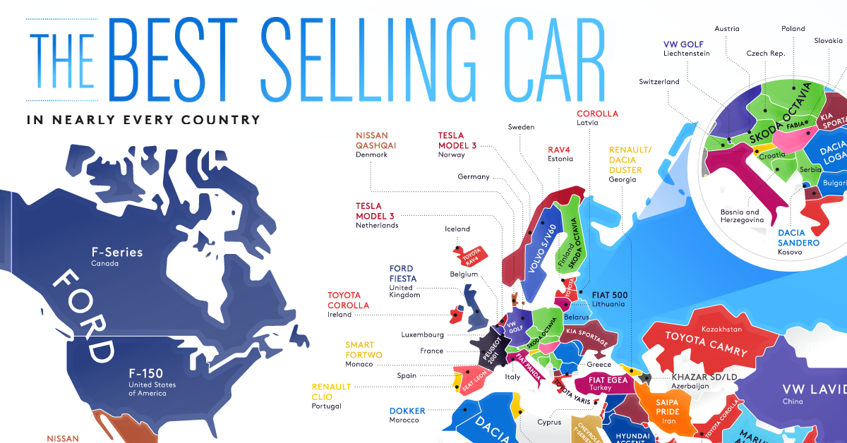
The Best-Selling Vehicles in the World By Country
View the full-size infographic map
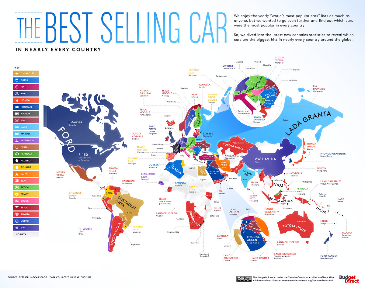
The Best-Selling Vehicles in the World By Country
Each country has different preferences for goods, and vehicles are no different.
Consumers in a dense country might prefer smaller cars, while countries with wide expanses (and parking spots) open the way for larger trucks. Likewise, rugged terrain might call for vehicles that can adapt and scale quickly.
And it’s also a question of which manufacturer invested in the country. As the world’s largest automakers have raced to attract consumers in every corner of the globe, they built factories, renamed models, and even built specific cars to fit the tastes of individual countries.
This infographic from Budget Direct Car Insurance highlights the best-selling vehicles in the world, using 2019 year-end sales data.
What is the Most Popular Vehicle in Each Country?
Though the map might vary across the board, one thing is certain: Toyota’s dominance.
The Japanese automaker—which was also the most valuable automaker in the world for many years before being overtaken by Tesla—had the best-selling vehicle in 41 countries of the 104 countries tallied.
It also had the world’s best-selling vehicle in 2019, the Toyota Corolla, though the sedan only took the top spot itself in five countries.
| Country | Best-Selling Vehicle | Type |
|---|---|---|
| Algeria | Dacia Sandero | Subcompact |
| American Samoa | Toyota Tacoma | Truck |
| Angola | Toyota Land Cruiser J70 | SUV |
| Argentina | Toyota Hilux | Truck |
| Australia | Toyota Hilux | Truck |
| Austria | Skoda Octavia | Sedan |
| Azerbaijan | Khazar SD/LD | Sedan |
| Bahrain | Toyota Land Cruiser | SUV |
| Belarus | Lada Vesta | Sedan |
| Belgium | VW Golf | Hatchback |
| Bosnia and Herzegovina | Skoda Octavia | Sedan |
| Botswana | Toyota Hilux | Truck |
| Brazil | Chevrolet Onix | Subcompact |
| Canada | Ford F-Series | Truck |
| Chile | Mitsubishi L-200 | Truck |
| China | VW Lavida | Sedan |
| Colombia | Renault Sandero | Subcompact |
| Cote d’Ivoire (Ivory Coast) | Toyota Hilux | Truck |
| Croatia | Skoda Octavia | Sedan |
| Cyprus | Toyota Yaris | Subcompact |
| Czech Republic | Skoda Octavia | Sedan |
| Denmark | Nissan Qashqai | SUV |
| Ecuador | Chevrolet Spark | Subcompact |
| Egypt | Chevrolet T-Series | Truck |
| Estonia | Toyota Rav4 | SUV |
| Fiji | Toyota Hilux | Truck |
| Finland | Skoda Octavia | Sedan |
| France | Peugeot 208 I | Subcompact |
| Georgia | Renault/Dacia Duster | SUV |
| Germany | VW Golf | Hatchback |
| Greece | Toyota Yaris | Subcompact |
| Hungary | Suzuki Vitara | SUV |
| Iceland | Toyota Rav4 | SUV |
| India | Maruti Alto | Hatchback |
| Indonesia | Toyota Avanza | Van |
| Iran | Saipa Pride | Sedan |
| Iraq | Kia Frontier | Truck |
| Ireland | Toyota Corolla | Sedan |
| Israel | Toyota Corolla | Sedan |
| Italy | Fiat Panda | Subcompact |
| Japan | Honda N-BOX | Subcompact |
| Jordan | Hyundai Tucson | SUV |
| Kazakhstan | Toyota Camry | Sedan |
| Kenya | Toyota Hilux | Truck |
| Kosovo | Dacia Sandero | Subcompact |
| Kuwait | Toyota Land Cruiser | SUV |
| Latvia | Toyota Corolla | Sedan |
| Lebanon | Toyota Land Cruiser | SUV |
| Lesotho | Toyota Hilux | Truck |
| Liechtenstein | VW Golf | Hatchback |
| Lithuania | Fiat 500 | Subcompact |
| Luxembourg | VW Golf | Hatchback |
| Macedonia | Kia Sportage | SUV |
| Malawi | Toyota Hilux | Truck |
| Malaysia | Perodua Myvi | Hatchback |
| Mexico | Nissan Versa | Sedan |
| Moldova | Dacia Logan | Sedan |
| Monaco | Smart Fortwo | Subcompact |
| Morocco | Dacia Dokker | Van |
| Namibia | Toyota Hilux | Truck |
| Netherlands | Tesla Model 3 | Sedan |
| New Zealand | Ford Ranger | Truck |
| Norway | Tesla Model 3 | Sedan |
| Oman | Toyota Land Cruiser | SUV |
| Pakistan | Toyota Corolla | Sedan |
| Panama | Toyota Hilux | Truck |
| Papua New Guinea | Toyota Land Cruiser J70 | SUV |
| Paraguay | Chevrolet Onix | Subcompact |
| Peru | Toyota Hilux | Truck |
| Philippines | Toyota Vios | Subcompact |
| Poland | Skoda Octavia | Sedan |
| Portugal | Renault Clio | Hatchback |
| Qatar | Toyota Land Cruiser | SUV |
| Romania | Dacia Logan | Sedan |
| Russia | Lada Granta | Subcompact |
| Samoa | Toyota Hiace | Van |
| Saudi Arabia | Hyundai Accent | Subcompact |
| Senegal | Mitsubishi L200 | Truck |
| Serbia | Skoda Octavia | Sedan |
| Singapore | Honda Vezel/HR-V | SUV |
| Slovakia | Skoda Fabia | Subcompact |
| Slovenia | Renault Clio | Hatchback |
| Solomon Islands | Toyota Hilux | Truck |
| South Africa | Toyota Hilux | Truck |
| South Korea | Hyundai Grandeur | Sedan |
| Spain | SEAT Leon | Hatchback |
| Sri Lanka | Suzuki Alto | Hatchback |
| Swaziland (Eswatini) | Toyota Hilux | Truck |
| Sweden | Volvo S/V60 | Sedan/Wagon |
| Switzerland | Skoda Octavia | Sedan |
| Syria | Hyundai Tucson | SUV |
| Taiwan | Toyota Corolla | Sedan |
| Thailand | Toyota Hilux | Truck |
| Tonga | Toyota Hilux | Truck |
| Tunisia | Renault Clio | Hatchback |
| Turkey | Fiat Egea | Sedan |
| Ukraine | Kia Sportage | SUV |
| United Arab Emirates | Toyota Land Cruiser | SUV |
| United Kingdom | Ford Fiesta | Subcompact |
| United States | Ford F-150 | Truck |
| Uruguay | Renault Kwid | Hatchback |
| Venezuela | Toyota Fortuner | SUV |
| Vietnam | Toyota Vios | Subcompact |
| Yemen | Toyota Land Cruiser | SUV |
As the best-seller in 16 countries, the Toyota Hilux truck (also known as the Toyota Pickup in North America) was the top vehicle in the most countries. It has a noticeably strong market share in the Southern Hemisphere, including in Argentina, South Africa, and Australia.
The other consistent factor was the strength of local manufacturers. Many countries with large automakers had local models as the best-selling vehicles, especially in Europe.
| Country with Local Best-Seller | Vehicle |
|---|---|
| Czech Republic | Škoda Octavia |
| France | Peugeot 208 I |
| Germany | VW Golf |
| India | Maruti Alto |
| Iran | SAIPA Pride |
| Italy | Fiat Panda |
| Japan | Honda N-BOX |
| Malaysia | Perodua Myvi |
| Romania | Dacia Logan |
| Russia | Lada Granta |
| South Korea | Hyundai Grandeur |
| Spain | SEAT León |
| Sweden | Volvo S/V60 |
| U.S. | Ford F-150 |
Cars are the Best-Selling Vehicles in the World
So what do car consumers currently prefer? Currently, cars have a slight edge over trucks as the best-selling vehicles in the world.
Of the 104 countries with sales tallied for the study, smaller cars often classified as “passenger vehicles” (including sedans, hatchbacks, and subcompacts) made up the majority of best-sellers, with 57 of the best-selling vehicles by country.
Meanwhile, “light trucks” or “light commercial vehicles,” which include trucks, SUVs, and vans, were best-sellers in 47 countries.
Best-Selling Vehicles by Type
- Hatchback: 12
- Sedan: 25
- Sedan/Wagon: 1
- Subcompact: 19
- SUV: 20
- Truck: 24
- Van: 3
But changing car consumption preferences are already making their mark. The electric vehicle (EV) Tesla Model 3 was already the best-selling vehicle in both the Netherlands and Norway, and other countries like China are increasing incentives for consumers to purchase EVs.
That’s not even factoring in the slowdown of travel during the COVID pandemic, more workers going remote, and the semiconductor strain on automakers. A truly post-COVID world will likely transform the map even further.


Maps
The Largest Earthquakes in the New York Area (1970-2024)
The earthquake that shook buildings across New York in April 2024 was the third-largest quake in the Northeast U.S. over the past 50 years.


The Largest Earthquakes in the New York Area
This was originally posted on our Voronoi app. Download the app for free on Apple or Android and discover incredible data-driven charts from a variety of trusted sources.
The 4.8 magnitude earthquake that shook buildings across New York on Friday, April 5th, 2024 was the third-largest quake in the U.S. Northeast area over the past 50 years.
In this map, we illustrate earthquakes with a magnitude of 4.0 or greater recorded in the Northeastern U.S. since 1970, according to the United States Geological Survey (USGS).
Shallow Quakes and Older Buildings
The earthquake that struck the U.S. Northeast in April 2024 was felt by millions of people from Washington, D.C., to north of Boston. It even caused a full ground stop at Newark Airport.
The quake, occurring just 5 km beneath the Earth’s surface, was considered shallow, which is what contributed to more intense shaking at the surface.
According to the USGS, rocks in the eastern U.S. are significantly older, denser, and harder than those on the western side, compressed by time. This makes them more efficient conduits for seismic energy. Additionally, buildings in the Northeast tend to be older and may not adhere to the latest earthquake codes.
Despite disrupting work and school life, the earthquake was considered minor, according to the Michigan Technological University magnitude scale:
| Magnitude | Earthquake Effects | Estimated Number Each Year |
|---|---|---|
| 2.5 or less | Usually not felt, but can be recorded by seismograph. | Millions |
| 2.5 to 5.4 | Often felt, but only causes minor damage. | 500,000 |
| 5.5 to 6.0 | Slight damage to buildings and other structures. | 350 |
| 6.1 to 6.9 | May cause a lot of damage in very populated areas. | 100 |
| 7.0 to 7.9 | Major earthquake. Serious damage. | 10-15 |
| 8.0 or greater | Great earthquake. Can totally destroy communities near the epicenter. | One every year or two |
The largest earthquake felt in the area over the past 50 years was a 5.3 magnitude quake that occurred in Au Sable Forks, New York, in 2002. It damaged houses and cracked roads in a remote corner of the Adirondack Mountains, but caused no injuries.
| Date | Magnitude | Location | State |
|---|---|---|---|
| April 20, 2002 | 5.3 | Au Sable Forks | New York |
| October 7, 1983 | 5.1 | Newcomb | New York |
| April 5, 2024 | 4.8 | Whitehouse Station | New Jersey |
| October 16, 2012 | 4.7 | Hollis Center | Maine |
| January 16, 1994 | 4.6 | Sinking Spring | Pennsylvania |
| January 19, 1982 | 4.5 | Sanbornton | New Hampshire |
| September 25, 1998 | 4.5 | Adamsville | Pennsylvania |
| June 9, 1975 | 4.2 | Altona | New York |
| May 29, 1983 | 4.2 | Peru | Maine |
| April 23, 1984 | 4.2 | Conestoga | Pennsylvania |
| January 16, 1994 | 4.2 | Sinking Spring | Pennsylvania |
| November 3, 1975 | 4 | Long Lake | New York |
| June 17, 1991 | 4 | Worcester | New York |
The largest earthquake in U.S. history, however, was the 1964 Good Friday quake in Alaska, measuring 9.2 magnitude and killing 131 people.

-

 Business2 weeks ago
America’s Top Companies by Revenue (1994 vs. 2023)
-

 Environment1 week ago
Ranked: Top Countries by Total Forest Loss Since 2001
-

 Real Estate1 week ago
Visualizing America’s Shortage of Affordable Homes
-

 Maps2 weeks ago
Mapped: Average Wages Across Europe
-

 Mining2 weeks ago
Charted: The Value Gap Between the Gold Price and Gold Miners
-

 Demographics2 weeks ago
Visualizing the Size of the Global Senior Population
-

 Misc2 weeks ago
Tesla Is Once Again the World’s Best-Selling EV Company
-

 Technology2 weeks ago
Ranked: The Most Popular Smartphone Brands in the U.S.