Education
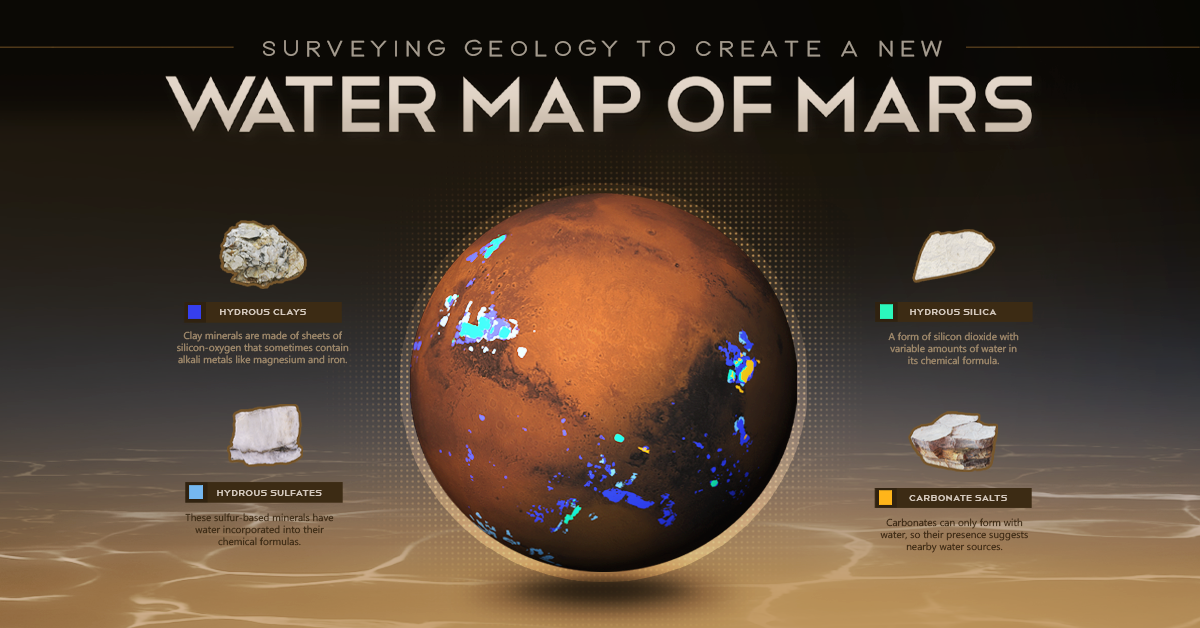
Animated Map: Where to Find Water on Mars


Animation: New Water Map of Mars
The hunt for water on Mars has always been a point of interest for researchers.
Earth has life almost everywhere water exists. Water is an ideal target for finding lifeforms, like microbes, that may exist on other planets.
And if Mars is to become a future home, knowing where water exists will be necessary for our survival.
Both NASA and the European Space Agency (ESA) have special instruments searching for water on the red planet. After 10 years of in-depth investigation, their latest findings suggest a new “water map” for Mars.
Where Did the Water Go?
Many people know Mars as a dry and dusty planet, but it hasn’t always been that way.
Approximately 4.1 to 3.8 billion years ago, Mars had a massive ocean called Oceanus Borealis. It dominated the northern hemisphere of the planet. Specific planetary conditions at that time let water exist on its surface. Changes in temperature, climate, and geology over the years gradually pushed water out to the atmosphere or into the ground.
Up to 99% of this ocean water is trapped within the planet’s crust, locked within special rocks called hydrous minerals.
Hydrous Minerals
Hydrous minerals are essentially rocks that have water (or its two main elements, hydrogen and oxygen), incorporated into their chemical structure.
There are four main classes of hydrous minerals: silicates, sulfates, silicas, and carbonates. While these minerals look pretty similar to the naked eye, their chemical compositions and structural arrangements vary. They are detectable by sophisticated equipment and can tell scientists how water geologically changes over time.
The new water map of Mars actually highlights the location of these hydrous minerals. It is a geological map of the rocks that are holding what remains of Mars’s ancient ocean.
Other Sources of Water on Mars
Despite being a “graveyard” for the bulk of the planet’s ocean, hydrous minerals are not the only source of water on Mars.
Water ice is present at both of Mars’s poles. The northern polar ice cap contains the only visible water on the planet, while the southern pole covers its water with a frozen carbon-dioxide cap.
In 2020, radar analyses suggested the presence of liquid water, potentially part of a network of underground saltwater lakes, close to the southern pole. In 2022, new evidence for this liquid water suggested that the planet may still be geothermally active.
More frozen water may be locked away in the deep subsurface, far below what current surveying equipment is able to inspect.
Mapping Out the Next Missions
The new water map is highlighting areas of interest for future exploration on Mars.
There is a small chance that hydrous minerals may be actively forming near water sources. Finding where they co-exist with known areas of buried frozen water provides possible opportunities for extracting water.
ESA’s Rosalind Franklin Rover will land in Oxia Planum, a region rich in hydrous clays, to investigate how water shaped the region and whether life once began on Mars.
Many more investigations and studies are developing, but for now, scientists are just getting their toes wet as they explore what hydrous minerals can tell us of Mars’s watery past.


Misc
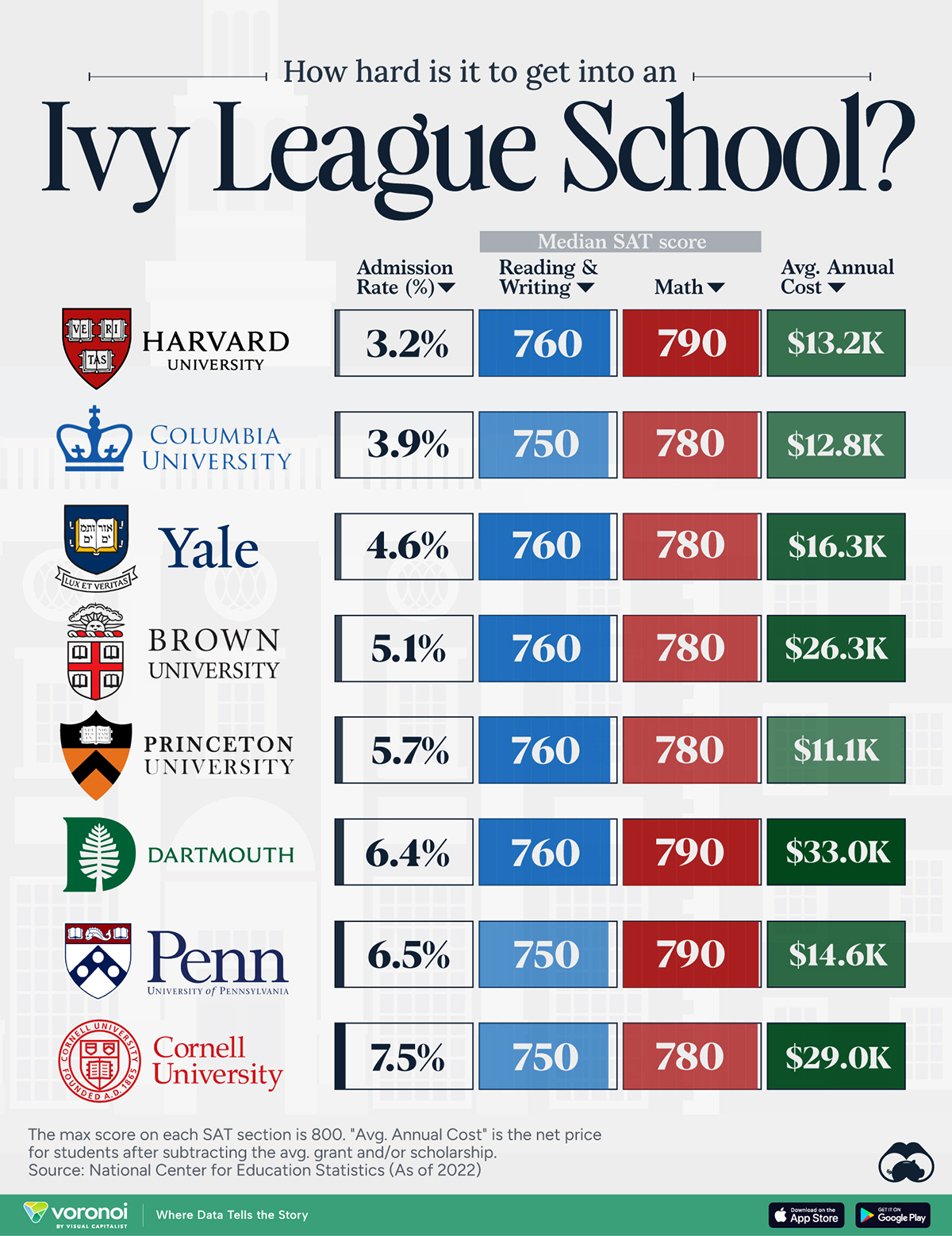
How Hard Is It to Get Into an Ivy League School?
We detail the admission rates and average annual cost for Ivy League schools, as well as the median SAT scores required to be accepted.
How Hard Is It to Get Into an Ivy League School?
This was originally posted on our Voronoi app. Download the app for free on iOS or Android and discover incredible data-driven charts from a variety of trusted sources.
Ivy League institutions are renowned worldwide for their academic excellence and long-standing traditions. But how hard is it to get into one of the top universities in the U.S.?
In this graphic, we detail the admission rates and average annual cost for Ivy League schools, as well as the median SAT scores required to be accepted. The data comes from the National Center for Education Statistics and was compiled by 24/7 Wall St.
Note that “average annual cost” represents the net price a student pays after subtracting the average value of grants and/or scholarships received.
Harvard is the Most Selective
The SAT is a standardized test commonly used for college admissions in the United States. It’s taken by high school juniors and seniors to assess their readiness for college-level academic work.
When comparing SAT scores, Harvard and Dartmouth are among the most challenging universities to gain admission to. The median SAT scores for their students are 760 for reading and writing and 790 for math. Still, Harvard has half the admission rate (3.2%) compared to Dartmouth (6.4%).
| School | Admission rate (%) | SAT Score: Reading & Writing | SAT Score: Math | Avg Annual Cost* |
|---|---|---|---|---|
| Harvard University | 3.2 | 760 | 790 | $13,259 |
| Columbia University | 3.9 | 750 | 780 | $12,836 |
| Yale University | 4.6 | 760 | 780 | $16,341 |
| Brown University | 5.1 | 760 | 780 | $26,308 |
| Princeton University | 5.7 | 760 | 780 | $11,080 |
| Dartmouth College | 6.4 | 760 | 790 | $33,023 |
| University of Pennsylvania | 6.5 | 750 | 790 | $14,851 |
| Cornell University | 7.5 | 750 | 780 | $29,011 |
*Costs after receiving federal financial aid.
Additionally, Dartmouth has the highest average annual cost at $33,000. Princeton has the lowest at $11,100.
While student debt has surged in the United States in recent years, hitting $1.73 trillion in 2023, the worth of obtaining a degree from any of the schools listed surpasses mere academics. This is evidenced by the substantial incomes earned by former students.
Harvard grads, for example, have the highest average starting salary in the country, at $91,700.

-

 Markets1 week ago
U.S. Debt Interest Payments Reach $1 Trillion
-

 Business2 weeks ago
Charted: Big Four Market Share by S&P 500 Audits
-

 Real Estate2 weeks ago
Ranked: The Most Valuable Housing Markets in America
-

 Money2 weeks ago
Which States Have the Highest Minimum Wage in America?
-

 AI2 weeks ago
Ranked: Semiconductor Companies by Industry Revenue Share
-

 Markets2 weeks ago
Ranked: The World’s Top Flight Routes, by Revenue
-

 Demographics2 weeks ago
Population Projections: The World’s 6 Largest Countries in 2075
-

 Markets2 weeks ago
The Top 10 States by Real GDP Growth in 2023